Geolocate

Port Royal topographic map

Click on the map to display elevation.

About this map

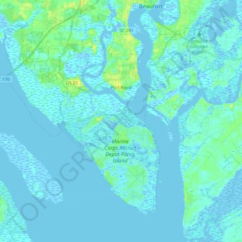
Name: Port Royal topographic map, elevation, terrain.

Location: Port Royal, Beaufort County, South Carolina, United States (32.29880 -80.84387 32.41520 -80.65823)

Average elevation: 2 m

Minimum elevation: -4 m

Maximum elevation: 17 m

Gear up for your next adventure:

🔥Emergency Fire Starter - Reliable ignition source for all weather conditions
🧢Outdoor Visor - Breathable visor for sunny hikes
🦌Outdoor Trail Camera - Monitor wildlife activity near your favorite spots
🧦Hiking Liner Socks - Thin base layer to prevent friction and blisters
🦯Trekking Poles - Reduced impact on joints for steep topographic climbs

As an Amazon Associate, this site earns from qualifying purchases at no extra cost to you.