
Picardy topographic map
Click on the map to display elevation.
About this map
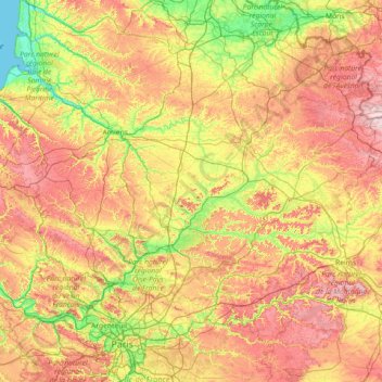
Name: Picardy topographic map, elevation, terrain.
Location: Picardy, Metropolitan France, France (48.83721 1.37983 50.36634 4.25575)
Average elevation: 114 m
Minimum elevation: 0 m
Maximum elevation: 331 m
Other topographic maps
Click on a map to view its topography, its elevation and its terrain.
Paris
Paris in its early history had only the rivers Seine and Bièvre for water. From 1809, the Canal de l'Ourcq provided Paris with water from less-polluted rivers to the north-east of the capital. From 1857, the civil engineer Eugène Belgrand, under Napoleon III, oversaw the construction of a series of new…
Average elevation: 75 m
Mont Blanc / Monte Bianco
France > Auvergne-Rhône-Alpes > Upper Savoy > Saint-Gervais-les-Bains
The climate is cold and temperate (Köppen climate classification Cfb), and is greatly influenced by altitude. Being the highest part of the Alps, Mont Blanc and surrounding mountains can create their own weather patterns. Temperatures drop as the mountains gain in height, and the summit of Mont Blanc is a…
Average elevation: 4,092 m
Les Mas de Guerrevieille
France > Provence-Alpes-Côte d'Azur > Var > Sainte-Maxime
Average elevation: 60 m
La Vieille Voie
France > Bourgogne – Franche-Comté > Haute-Saône > Corravillers
Average elevation: 593 m
Aix-en-Provence
France > Provence-Alpes-Côte d'Azur > Bouches-du-Rhône > Aix-en-Provence
Average elevation: 279 m
Plan de Campagne
France > Provence-Alpes-Côte d'Azur > Bouches-du-Rhône > Les Pennes-Mirabeau
Average elevation: 231 m
La Binetterie
France > Pays de la Loire > Mayenne > Château-Gontier-sur-Mayenne
Average elevation: 60 m
Coustères
France > Nouvelle-Aquitaine > Pyrénées-Atlantiques > Salies-de-Béarn
Average elevation: 81 m
La Folie
France > Bourgogne – Franche-Comté > Yonne > Charny Orée de Puisaye > Saint-Martin-sur-Ouanne
Average elevation: 174 m
Sous Les Coteaux de Charmo
France > Bourgogne – Franche-Comté > Côte-d'Or > Avot
Average elevation: 411 m
La Côte de Marlens
France > Auvergne-Rhône-Alpes > Upper Savoy > Val de Chaise
Average elevation: 735 m
Pic Gaspard
France > Provence-Alpes-Côte d'Azur > Hautes-Alpes > Villar-d'Arêne
Average elevation: 3,145 m
Moulin de la Ville
France > Bourgogne – Franche-Comté > Saône-et-Loire > Chagny
Average elevation: 219 m
Pont de Chazeaux
France > Auvergne-Rhône-Alpes > Haute-Loire > Monistrol-sur-Loire
Average elevation: 731 m
Les Champs
France > Auvergne-Rhône-Alpes > Upper Savoy > Saint-Jean-d'Aulps
Average elevation: 1,194 m
Le Barnagaud
France > Nouvelle-Aquitaine > Haute-Vienne > La Croisille-sur-Briance
Average elevation: 550 m
Le Haut de la Beuille
France > Bourgogne – Franche-Comté > Haute-Saône > Fougerolles-Saint-Valbert
Average elevation: 372 m
Argentière
France > Auvergne-Rhône-Alpes > Upper Savoy > Chamonix-Mont-Blanc
Argentière (French pronunciation: [aʁʒɑ̃tjɛʁ]) is a picturesque skiing, alpine walking and mountaineering village in the French Alps, part of the commune of Chamonix-Mont-Blanc, at an altitude of 1,252 m (4,108 ft).
Average elevation: 1,674 m
Saint-Michel
France > Provence-Alpes-Côte d'Azur > Alpes-de-Haute-Provence > Moustiers-Sainte-Marie
Average elevation: 731 m
Mer de Glace
France > Auvergne-Rhône-Alpes > Upper Savoy > Chamonix-Mont-Blanc
The glacier lies above the Chamonix valley. The pressure within the ice is known to reach at least 30 atmospheres. The Mer de Glace can be considered as originating at an elevation of 2,100 metres (6,900 ft), just north of the Aiguille du Tacul, where it is formed by the confluence of the Glacier de Leschaux…
Average elevation: 2,323 m
Chateauneuf de Mazenc
France > Auvergne-Rhône-Alpes > Drôme > La Bégude-de-Mazenc
Average elevation: 238 m
Bayonne
France > New Aquitaine > Pyrénées-Atlantiques > Bayonne > Bayonne
In the late Quaternary, the current topographic physiognomy was formed—i.e. a set of hills overlooking a swampy lowland. The promontory of Bassussarry–Marracq ultimately extended to the Labourdin foothills. The Grand Bayonne hill is an example. Similarly, on the right bank of the Nive, the heights of…
Average elevation: 23 m