Geolocate

Edmund topographic map

Click on the map to display elevation.

About this map

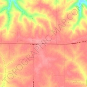
Name: Edmund topographic map, elevation, terrain.

Location: Edmund, Town of Linden, Iowa County, Wisconsin, 53535, United States (42.94763 -90.28438 42.98763 -90.24438)

Average elevation: 351 m

Minimum elevation: 279 m

Maximum elevation: 373 m

Other topographic maps

Click on a map to view its topography, its elevation and its terrain.

Avoca

United States > Wisconsin > Iowa County

Average elevation: 217 m

Rewey

United States > Wisconsin > Iowa County

Average elevation: 333 m

Linden

United States > Wisconsin > Iowa County

Average elevation: 332 m

Town of Brigham

United States > Wisconsin > Iowa County

Average elevation: 330 m

Cobb

United States > Wisconsin > Iowa County

Average elevation: 359 m

Highland

United States > Wisconsin > Iowa County

Average elevation: 353 m

Town of Moscow

United States > Wisconsin > Iowa County

Average elevation: 293 m

Barneveld

United States > Wisconsin > Iowa County

Average elevation: 350 m

Ridgeway

United States > Wisconsin > Iowa County

Average elevation: 338 m

Gear up for your next adventure:

🧥Waterproof Jacket - Lightweight rain jackets for hiking and outdoor activities
🥾Mountaineering Boots - Supportive boots for climbing and high-altitude hiking
🕯️Camping Lantern - Illuminates your entire campsite with high-efficiency LEDs
👟Trail Running Shoes - Agile footwear for fast-paced topographic exploration
🧦Hiking Liner Socks - Thin base layer to prevent friction and blisters

As an Amazon Associate, this site earns from qualifying purchases at no extra cost to you.