Geolocate

Highland topographic map

Click on the map to display elevation.

About this map

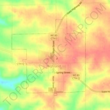
Name: Highland topographic map, elevation, terrain.

Location: Highland, Iowa County, Wisconsin, United States (43.03867 -90.39441 43.05866 -90.36957)

Average elevation: 353 m

Minimum elevation: 308 m

Maximum elevation: 377 m

Other topographic maps

Click on a map to view its topography, its elevation and its terrain.

Edmund

United States > Wisconsin > Iowa County

Average elevation: 351 m

Jonesdale

United States > Wisconsin > Iowa County

Average elevation: 306 m

Blue Mounds

United States > Wisconsin > Iowa County

Average elevation: 417 m

Gear up for your next adventure:

🪑Ultralight Camping Stool - Compact seating for rest stops during long hikes
🧢Outdoor Visor - Breathable visor for sunny hikes
💧Reusable Water Bottle - Durable water bottles for hydration on trails
🔭Compact Binoculars - Lightweight optics for scouting trails and wildlife
🔦LED Headlamp - Hands-free lighting for early morning starts or late finishes

As an Amazon Associate, this site earns from qualifying purchases at no extra cost to you.