Geolocate

Avoca topographic map

Click on the map to display elevation.

About this map

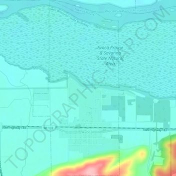
Name: Avoca topographic map, elevation, terrain.

Location: Avoca, Iowa County, Wisconsin, United States (43.17284 -90.34039 43.20956 -90.31438)

Average elevation: 217 m

Minimum elevation: 196 m

Maximum elevation: 340 m

Other topographic maps

Click on a map to view its topography, its elevation and its terrain.

Edmund

United States > Wisconsin > Iowa County

Average elevation: 351 m

Jonesdale

United States > Wisconsin > Iowa County

Average elevation: 306 m

Blue Mounds

United States > Wisconsin > Iowa County

Average elevation: 417 m

Gear up for your next adventure:

🕶️Polarized Sunglasses - Protect your eyes with durable polarized lenses
🧴Waterproofing Spray - Restore the DWR coating on jackets and tents
👟Trail Running Shoes - Agile footwear for fast-paced topographic exploration
🔭Outdoor Binoculars - Lightweight binoculars for birdwatching and hiking
🧤Insulated Winter Gloves - Heavy-duty protection for sub-zero Canadian adventures

As an Amazon Associate, this site earns from qualifying purchases at no extra cost to you.