
Alsace topographic map
Click on the map to display elevation.
Alsace
Alsace has a semi-continental climate at low altitude and a continental climate at high altitude. There is fairly low precipitation because the Vosges protect it from the west. The city of Colmar has a sunny microclimate; it is the second driest city in France, with an annual precipitation of 600 mm, making it ideal for vin d'Alsace (Alsatian wine).
About this map
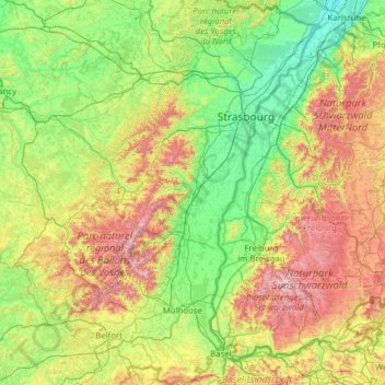
Name: Alsace topographic map, elevation, terrain.
Location: Alsace, Metropolitan France, France (47.42034 6.84132 49.07779 8.23285)
Average elevation: 414 m
Minimum elevation: 100 m
Maximum elevation: 1,471 m
Other topographic maps
Click on a map to view its topography, its elevation and its terrain.
Paris
Paris in its early history had only the rivers Seine and Bièvre for water. From 1809, the Canal de l'Ourcq provided Paris with water from less-polluted rivers to the north-east of the capital. From 1857, the civil engineer Eugène Belgrand, under Napoleon III, oversaw the construction of a series of new…
Average elevation: 75 m
Luz-Saint-Sauveur
France > Occitania > Hautes Pyrenees > Luz-Saint-Sauveur > Luz-Saint-Sauveur
Average elevation: 1,035 m
Aiguille du Midi
France > Auvergne-Rhône-Alpes > Upper Savoy > Chamonix-Mont-Blanc
Average elevation: 3,097 m
Pointe du Hoc
France > Normandy > Calvados > Cricqueville-en-Bessin > Le Pont du Hable
Average elevation: 12 m
Pont du Loup
France > Provence-Alpes-Côte d'Azur > Maritime Alps > Tourrettes-sur-Loup
Average elevation: 607 m
Chamonix-Mont-Blanc
France > Auvergne-Rhône-Alpes > Upper Savoy > Chamonix-Mont-Blanc > Chamonix-Mont-Blanc
Average elevation: 1,787 m
Plan de la Loubiere
France > Provence-Alpes-Côte d'Azur > Hautes-Alpes > La Roche-de-Rame
Average elevation: 2,056 m
Crecy
France > Auvergne-Rhône-Alpes > Métropole de Lyon > Saint-Didier-au-Mont-d'Or
Average elevation: 262 m
Cime de la Bonette
France > Provence-Alpes-Côte d'Azur > Maritime Alps > Saint-Dalmas-le-Selvage
Average elevation: 2,512 m
Serre Chevalier
France > Provence-Alpes-Côte d'Azur > Hautes-Alpes > Puy-Saint-André
The maximum elevation for skiing is at Telesiege Yret at 2,800 m (9,190 ft) above sea level, and the minimum is 1,200 m (3,940 ft), a total vertical drop of 1,600 m (5,250 ft). One of the outstanding features of Serre Chevalier is the wooded nature of the slopes. The timber line is at 2,150 m (7,050 ft),…
Average elevation: 2,256 m
La Vieille-Ville
France > Pays de la Loire > Loire-Atlantique > La Chapelle-Glain
Average elevation: 72 m
Etang des Lames
France > Bourgogne – Franche-Comté > Yonne > Island > La Courcelle
Average elevation: 281 m
Mollard Durand
France > Auvergne-Rhône-Alpes > Savoy > Saint-Martin-de-la-Porte
Average elevation: 1,050 m
Jardins de la Rainville
France > Centre-Val de Loire > Eure-et-Loir > Châteaudun
Average elevation: 131 m
La Gravette
France > Provence-Alpes-Côte d'Azur > Alpes-de-Haute-Provence > Barcelonnette
Average elevation: 1,282 m
Mont Puget
France > Provence-Alpes-Côte d'Azur > Bouches-du-Rhône > Marseille
Average elevation: 289 m
Logis Du Fenestreau
France > Pays de la Loire > Vendée > Les Sables-d'Olonne > Les Soulardières
Average elevation: 31 m
Lucis
France > Provence-Alpes-Côte d'Azur > Hautes-Alpes > Villar-Saint-Pancrace
Average elevation: 1,326 m
Le Moulin Géant
France > Pays de la Loire > Maine-et-Loire > Rochefort-sur-Loire
Average elevation: 46 m
Plage du Canon
France > Provence-Alpes-Côte d'Azur > Var > Saint-Mandrier-sur-Mer
Average elevation: 18 m
Bayonne
France > New Aquitaine > Pyrénées-Atlantiques > Bayonne > Bayonne
In the late Quaternary, the current topographic physiognomy was formed—i.e. a set of hills overlooking a swampy lowland. The promontory of Bassussarry–Marracq ultimately extended to the Labourdin foothills. The Grand Bayonne hill is an example. Similarly, on the right bank of the Nive, the heights of…
Average elevation: 23 m
Col du Lautaret
France > Provence-Alpes-Côte d'Azur > Hautes-Alpes > Le Monêtier-les-Bains
From the west, the climb starts at Les Clapier, near Le Bourg-d'Oisans, from where the climb is 34.2 km (21.3 mi) long, gaining 1,312 m (4,304 ft) in altitude, at an average gradient of 3.8%, with the steepest section being at 7.5% in the first kilometre.
Average elevation: 2,261 m
La Vrillonerie
France > Centre-Val de Loire > Indre-et-Loire > Chambray-lès-Tours
Average elevation: 89 m