
Innsbruck topographic map
Interactive map
Click on the map to display elevation.
About this map
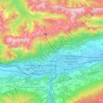
Name: Innsbruck topographic map, elevation, terrain.
Location: Innsbruck, Austria (47.21077 11.30164 47.36013 11.45596)
Average elevation: 1,280 m
Minimum elevation: 558 m
Maximum elevation: 2,668 m
Other topographic maps
Click on a map to view its topography, its elevation and its terrain.
Lahnberg
Austria > Lower Austria > Bezirk Neunkirchen > Schwarzau im Gebirge
Average elevation: 1,213 m
Klagenfurt Land
Austria > Carinthia > Bezirk Klagenfurt-Land > Krumpendorf am Wörthersee
Average elevation: 894 m
Bad Eisenkappel/Železna Kapla
Austria > Carinthia > Bezirk Völkermarkt > Eisenkappel-Vellach
Average elevation: 914 m