
Revelstoke topographic map
Interactive map
Click on the map to display elevation.
Revelstoke
A small ski resort featuring a single short lift has operated on Mount MacKenzie since the 1960s, and snowcat skiing was offered for higher altitudes. A strong movement pushed to expand the entire mountain into a single resort, and construction started in the early 2000s (decade).
About this map
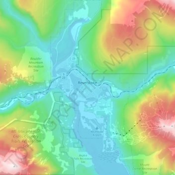
Name: Revelstoke topographic map, elevation, terrain.
Average elevation: 982 m
Minimum elevation: 431 m
Maximum elevation: 2,427 m
Columbia-Shuswap Regional District trails, hiking, mountain biking, running and outdoor activities
Other topographic maps
Click on a map to view its topography, its elevation and its terrain.
Mount Huber
Canada > British Columbia > Columbia-Shuswap Regional District > Area A (Kicking Horse/Kinbasket Lake)
Average elevation: 2,662 m
Blaeberry
Canada > British Columbia > Columbia-Shuswap Regional District > Area A (Kicking Horse/Kinbasket Lake)
Average elevation: 846 m
Silvertip Mountain
Canada > British Columbia > Columbia-Shuswap Regional District > Area A (Kicking Horse/Kinbasket Lake)
Average elevation: 2,443 m
Blind Bay
Canada > British Columbia > Columbia-Shuswap Regional District > Area C (Blind Bay/Sorrento)
Average elevation: 414 m
Rockwall Peak
Canada > British Columbia > Columbia-Shuswap Regional District > Area A (Kicking Horse/Kinbasket Lake)
Average elevation: 2,431 m
Mount Burgess
Canada > British Columbia > Columbia-Shuswap Regional District > Area A (Kicking Horse/Kinbasket Lake)
Average elevation: 1,938 m
Donald
Canada > British Columbia > Columbia-Shuswap Regional District > Area A (Kicking Horse/Kinbasket Lake)
Average elevation: 820 m
Beaverfoot Range
Canada > British Columbia > Columbia-Shuswap Regional District > Area A (Kicking Horse/Kinbasket Lake)
Average elevation: 2,123 m
Larch Hills
Canada > British Columbia > Columbia-Shuswap Regional District > Area E (Eagle River Valley)
Average elevation: 1,225 m
Mount Goodsir
Canada > British Columbia > Columbia-Shuswap Regional District > Area A (Kicking Horse/Kinbasket Lake)
Average elevation: 2,633 m
Mount Clemenceau
Canada > British Columbia > Columbia-Shuswap Regional District > Area A (Kicking Horse/Kinbasket Lake)
Average elevation: 2,928 m
Sherbrooke Lake
Canada > British Columbia > Columbia-Shuswap Regional District > Area A (Kicking Horse/Kinbasket Lake)
Average elevation: 2,080 m
Field
Canada > British Columbia > Columbia-Shuswap Regional District > Area A (Kicking Horse/Kinbasket Lake)
Field is an unincorporated community of approximately 169 people located in the Kicking Horse River valley of southeastern British Columbia, Canada, within the confines of Yoho National Park. At an elevation of 1,256 m (4,121 ft), it is 27 km (17 mi) west of Lake Louise along the Trans-Canada Highway, which…
Average elevation: 1,593 m
Quinn Peak
Canada > British Columbia > Columbia-Shuswap Regional District > Area A (Kicking Horse/Kinbasket Lake)
Average elevation: 1,981 m
Magna Bay
Canada > British Columbia > Columbia-Shuswap Regional District > Area F (Scotch Creek/Seymour Arm)
Average elevation: 412 m
Malakwa
Canada > British Columbia > Columbia-Shuswap Regional District > Area E (Eagle River Valley)
Average elevation: 470 m
Trout Lake
Canada > British Columbia > Columbia-Shuswap Regional District > Area B (Shelter Bay/Mica Creek)
Average elevation: 823 m
Joyce Lake
Canada > British Columbia > Columbia-Shuswap Regional District > Area D (Falkland/Silver Creek)
Average elevation: 954 m
International Mountain
Canada > British Columbia > Columbia-Shuswap Regional District > Area A (Kicking Horse/Kinbasket Lake)
Average elevation: 2,583 m
Anglemont
Canada > British Columbia > Columbia-Shuswap Regional District > Area F (Scotch Creek/Seymour Arm)
Average elevation: 426 m
Wapta Lake
Canada > British Columbia > Columbia-Shuswap Regional District > Area A (Kicking Horse/Kinbasket Lake)
Average elevation: 1,757 m
Lake O'Hara
Canada > British Columbia > Columbia-Shuswap Regional District > Area A (Kicking Horse/Kinbasket Lake)
Lake O'Hara is a lake at an elevation of 2,020 metres (6,630 ft) in the alpine area of Yoho National Park, in the province of British Columbia, on the western side of the Great Divide with the province of Alberta and Banff National Park to the east. The lake and the valley are accessible through a bus service…
Average elevation: 2,276 m
White Lake
Canada > British Columbia > Columbia-Shuswap Regional District > Area C (Blind Bay/Sorrento)
Average elevation: 606 m
Scotch Creek
Canada > British Columbia > Columbia-Shuswap Regional District > Area F (Scotch Creek/Seymour Arm)
Average elevation: 1,125 m
Quartz Creek
Canada > British Columbia > Columbia-Shuswap Regional District > Area A (Kicking Horse/Kinbasket Lake)
Average elevation: 1,352 m
Falkland
Canada > British Columbia > Columbia-Shuswap Regional District > Area D (Falkland/Silver Creek)
Average elevation: 786 m
Sicamous Lookout
Canada > British Columbia > Columbia-Shuswap Regional District > Sicamous
Average elevation: 911 m
Mount Begbie
Canada > British Columbia > Columbia-Shuswap Regional District > Area B (Shelter Bay/Mica Creek)
Average elevation: 2,066 m
Apex Mountain
Canada > British Columbia > Columbia-Shuswap Regional District > Area A (Kicking Horse/Kinbasket Lake)
Average elevation: 2,793 m
Wapta Falls
Canada > British Columbia > Columbia-Shuswap Regional District > Area A (Kicking Horse/Kinbasket Lake)
Average elevation: 1,145 m
Salmon Arm
Canada > British Columbia > Columbia-Shuswap Regional District > Salmon Arm > Salmon Arm
Average elevation: 479 m
Revelstoke
Canada > British Columbia > Columbia-Shuswap Regional District > Revelstoke
Average elevation: 1,399 m
Charity Peak
Canada > British Columbia > Columbia-Shuswap Regional District > Area B (Shelter Bay/Mica Creek)
Average elevation: 2,461 m
Faith Peak
Canada > British Columbia > Columbia-Shuswap Regional District > Area B (Shelter Bay/Mica Creek)
Average elevation: 2,349 m
Mara Lake
Canada > British Columbia > Columbia-Shuswap Regional District > Area E (Eagle River Valley) > Swansea Point
The lake is 35.3 kilometres (21.9 mi) long. The surface area is about 1,943 hectares (4,800 acres) and elevation is 338 metres (1,109 ft) above sea level. The mean and maximum depth is 18 metres (59 ft).
Average elevation: 826 m
Seymour Arm
Canada > British Columbia > Columbia-Shuswap Regional District > Area F (Scotch Creek/Seymour Arm)
Average elevation: 381 m
Seymour Arm
Canada > British Columbia > Columbia-Shuswap Regional District > Area F (Scotch Creek/Seymour Arm)
Average elevation: 381 m
McMurdo
Canada > British Columbia > Columbia-Shuswap Regional District > Area A (Kicking Horse/Kinbasket Lake)
Average elevation: 852 m
McMurdo
Canada > British Columbia > Columbia-Shuswap Regional District > Area A (Kicking Horse/Kinbasket Lake)
Average elevation: 852 m
Mount English
Canada > British Columbia > Columbia-Shuswap Regional District > Area E (Eagle River Valley)
Average elevation: 2,169 m
Eagle Bay
Canada > British Columbia > Columbia-Shuswap Regional District > Area C (Blind Bay/Sorrento)
Average elevation: 497 m
Celista
Canada > British Columbia > Columbia-Shuswap Regional District > Area F (Scotch Creek/Seymour Arm)
Average elevation: 407 m
Sorrento
Canada > British Columbia > Columbia-Shuswap Regional District > Area C (Blind Bay/Sorrento)
Average elevation: 434 m
Kicking Horse Mountain Resort
Canada > British Columbia > Columbia-Shuswap Regional District > Area A (Kicking Horse/Kinbasket Lake)
Average elevation: 1,382 m
Arthur O. Wheeler Hut
Canada > British Columbia > Columbia-Shuswap Regional District > Area B (Shelter Bay/Mica Creek)
Average elevation: 1,561 m
Emerald Lake
Canada > British Columbia > Columbia-Shuswap Regional District > Area A (Kicking Horse/Kinbasket Lake)
The lake is enclosed by mountains of the President Range, as well as Mount Burgess and Wapta Mountain. This basin traps storms, causing frequent rain in summer and heavy snowfalls in winter. This influx of moisture works with the lake's low elevation to produce a unique selection of flora. Trees found here are…
Average elevation: 1,413 m
Skimikin Lake
Canada > British Columbia > Columbia-Shuswap Regional District > Area C (Blind Bay/Sorrento)
Average elevation: 659 m