
Make a donation
Gear up for your next adventure:
As an Amazon Associate, this site earns from qualifying purchases at no extra cost to you.
International Mountain topographic map
Click on the map to display elevation.
Make a donation
Gear up for your next adventure:
As an Amazon Associate, this site earns from qualifying purchases at no extra cost to you.
About this map
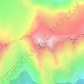
Name: International Mountain topographic map, elevation, terrain.
Average elevation: 2,583 m
Minimum elevation: 2,027 m
Maximum elevation: 3,088 m
Columbia-Shuswap Regional District trails, hiking, mountain biking, running and outdoor activities
Make a donation
Gear up for your next adventure:
As an Amazon Associate, this site earns from qualifying purchases at no extra cost to you.
Other topographic maps
Click on a map to view its topography, its elevation and its terrain.
Lake O'Hara
Canada > British Columbia > Columbia-Shuswap Regional District > Area A (Kicking Horse/Kinbasket Lake)
Lake O'Hara is a lake at an elevation of 2,020 metres (6,630 ft) in the alpine area of Yoho National Park, in the province of British Columbia, on the western side of the Great Divide with the province of Alberta and Banff National Park to the east. The lake and the valley are accessible through a bus service…
Average elevation: 2,276 m
Sherbrooke Lake
Canada > British Columbia > Columbia-Shuswap Regional District > Area A (Kicking Horse/Kinbasket Lake)
Average elevation: 2,080 m
Windy Arm
Canada > British Columbia > Columbia-Shuswap Regional District > Area A (Kicking Horse/Kinbasket Lake)
Average elevation: 1,009 m
Wapta Falls
Canada > British Columbia > Columbia-Shuswap Regional District > Area A (Kicking Horse/Kinbasket Lake)
Average elevation: 1,145 m
Make a donation
Gear up for your next adventure:
As an Amazon Associate, this site earns from qualifying purchases at no extra cost to you.
Quartz Creek
Canada > British Columbia > Columbia-Shuswap Regional District > Area A (Kicking Horse/Kinbasket Lake)
Average elevation: 1,352 m
Wapta Lake
Canada > British Columbia > Columbia-Shuswap Regional District > Area A (Kicking Horse/Kinbasket Lake)
Average elevation: 1,757 m
Takakkaw Lake
Canada > British Columbia > Columbia-Shuswap Regional District > Area A (Kicking Horse/Kinbasket Lake)
Average elevation: 2,143 m
Stanley Glacier
Canada > British Columbia > Columbia-Shuswap Regional District > Area A (Kicking Horse/Kinbasket Lake)
Average elevation: 2,488 m
Make a donation
Gear up for your next adventure:
As an Amazon Associate, this site earns from qualifying purchases at no extra cost to you.
Wapta Icefield
Canada > British Columbia > Columbia-Shuswap Regional District > Area A (Kicking Horse/Kinbasket Lake)
Average elevation: 2,564 m
Waputik Icefield
Canada > British Columbia > Columbia-Shuswap Regional District > Area A (Kicking Horse/Kinbasket Lake)
Average elevation: 2,432 m
Rogers Glacier
Canada > British Columbia > Columbia-Shuswap Regional District > Area A (Kicking Horse/Kinbasket Lake)
Average elevation: 2,499 m
Bugaboo Provincial Park
Canada > British Columbia > Columbia-Shuswap Regional District > Area A (Kicking Horse/Kinbasket Lake)
Average elevation: 2,192 m
Make a donation
Gear up for your next adventure:
As an Amazon Associate, this site earns from qualifying purchases at no extra cost to you.
Forbes Glacier
Canada > British Columbia > Columbia-Shuswap Regional District > Area A (Kicking Horse/Kinbasket Lake)
Average elevation: 2,476 m
Shackleton Glacier
Canada > British Columbia > Columbia-Shuswap Regional District > Area A (Kicking Horse/Kinbasket Lake)
Average elevation: 2,446 m
Emerald Lake
Canada > British Columbia > Columbia-Shuswap Regional District > Area A (Kicking Horse/Kinbasket Lake)
Many wild animals live in the area and are protected by Park Law, Brown (Grizzly) Bears and Black Bears are fairly common, they co-exist quite well with humans as the Park has strict laws on garbage control and good advice to Park Visitors on practicing bear safety and being "Bear Aware". Mountain Goats and…
Average elevation: 1,413 m
Lake O'Hara
Canada > British Columbia > Columbia-Shuswap Regional District > Area A (Kicking Horse/Kinbasket Lake)
Lake O'Hara is a lake at an elevation of 2,020 metres (6,630 ft) in the alpine area of Yoho National Park, in the province of British Columbia, on the western side of the Great Divide with the province of Alberta and Banff National Park to the east. The lake and the valley are accessible through a bus service…
Average elevation: 2,276 m
Make a donation
Gear up for your next adventure:
As an Amazon Associate, this site earns from qualifying purchases at no extra cost to you.
Emerald Lake
Canada > British Columbia > Columbia-Shuswap Regional District > Area A (Kicking Horse/Kinbasket Lake)
Many wild animals live in the area and are protected by Park Law, Brown (Grizzly) Bears and Black Bears are fairly common, they co-exist quite well with humans as the Park has strict laws on garbage control and good advice to Park Visitors on practicing bear safety and being "Bear Aware". Mountain Goats and…
Average elevation: 1,413 m
Harvey Bay
Canada > British Columbia > Columbia-Shuswap Regional District > Area A (Kicking Horse/Kinbasket Lake)
Average elevation: 977 m