
Make a donation
Gear up for your next adventure:
As an Amazon Associate, this site earns from qualifying purchases at no extra cost to you.
Caribbean topographic map
Click on the map to display elevation.
Make a donation
Gear up for your next adventure:
As an Amazon Associate, this site earns from qualifying purchases at no extra cost to you.
Caribbean
Rainfall varies with elevation, size and water currents, such as the cool upwellings that keep the ABC islands arid. Warm, moist trade winds blow consistently from the east, creating both rain forest and semi arid climates across the region. The tropical rainforest climates include lowland areas near the Caribbean Sea from Costa Rica north to Belize, as well as the Dominican Republic and Puerto Rico, while the more seasonal dry tropical savanna climates are found in Cuba, northern Colombia and Venezuela, and southern Yucatán, Mexico. Arid climates are found along the extreme northern coast of Venezuela out to the islands including Aruba and Curacao, as well as the northwestern tip of Yucatán.
Make a donation
Gear up for your next adventure:
As an Amazon Associate, this site earns from qualifying purchases at no extra cost to you.
About this map
Name: Caribbean topographic map, elevation, terrain.
Location: Caribbean, Haiti (17.40000 -76.00000 19.40000 -74.00000)
Average elevation: 20 m
Minimum elevation: 0 m
Maximum elevation: 2,266 m
Make a donation
Gear up for your next adventure:
As an Amazon Associate, this site earns from qualifying purchases at no extra cost to you.
Other topographic maps
Click on a map to view its topography, its elevation and its terrain.
Make a donation
Gear up for your next adventure:
As an Amazon Associate, this site earns from qualifying purchases at no extra cost to you.
Make a donation
Gear up for your next adventure:
As an Amazon Associate, this site earns from qualifying purchases at no extra cost to you.
Département du Nord
The department is bordered to the north by the Atlantic Ocean, to the west by the N-O, the South by the Artibonite, and to the east by the N-E. Topographically, its territory is separated between the Plain of the North or Caracol Plain from Limbé to Samana and the Massif of the North or the Cordillera…
Average elevation: 297 m
Centre Department
The Centre department is a high plateau topographical region. Due to its isolation if one of the greenest departments.
Average elevation: 515 m
Make a donation
Gear up for your next adventure:
As an Amazon Associate, this site earns from qualifying purchases at no extra cost to you.
Département du Nord
The department is bordered to the north by the Atlantic Ocean, to the west by the N-O, the South by the Artibonite, and to the east by the N-E. Topographically, its territory is separated between the Plain of the North or Caracol Plain from Limbé to Samana and the Massif of the North or the Cordillera…
Average elevation: 297 m
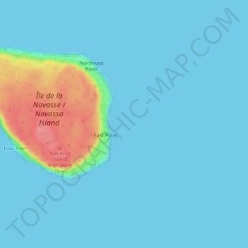
Île de la Navasse / Navassa Island
Navassa reaches an elevation of 250 feet (76 m) at Dunning Hill 110 yards (100 m) south of the lighthouse, Navassa Island Light. This location is 440 yards (400 m) from the southwestern coast or 655 yards (600 m) east of Lulu Bay.
Average elevation: 28 m
Make a donation
Gear up for your next adventure:
As an Amazon Associate, this site earns from qualifying purchases at no extra cost to you.
Gonâve Island
Made up of mostly limestone, the reef-fringed island of Gonâve is 60 km (37 mi) long and 15 km (9 mi) wide and covers an area of 743 km2 (287 sq mi). The island is mostly barren and hilly with the highest point reaching 778 m (2,552 ft). The island receives between 800 mm (31 in) to 1,600 mm (63 in) of rain a…
Average elevation: 54 m
Île-à-Vache
Haiti > Sud Department > Commune Île-à-Vache
The island is about 8 miles (13 km) long and 2 miles (3.2 km) wide, with an area of 20 square miles (52 km2). The western end of the island has rolling hills with elevations as high as 490 feet (150 m) with several small swamps in the valleys; the eastern side of the island is swampy, and contains a lagoon…
Average elevation: 2 m
Département du Nord
The department is bordered to the north by the Atlantic Ocean, to the west by the N-O, the South by the Artibonite, and to the east by the N-E. Topographically, its territory is separated between the Plain of the North or Caracol Plain from Limbé to Samana and the Massif of the North or the Cordillera…
Average elevation: 297 m
Make a donation
Gear up for your next adventure:
As an Amazon Associate, this site earns from qualifying purchases at no extra cost to you.
Make a donation
Gear up for your next adventure:
As an Amazon Associate, this site earns from qualifying purchases at no extra cost to you.
Ravine Nan Gola
Haiti > Nord-Ouest Department > Commune Jean Rabel > Jean-Rabel
Average elevation: 188 m
Port-au-Prince Arrondissement
By then, the colonial administration was convinced that a capital needed to be chosen, in order to better control the French portion of Hispaniola (Saint-Domingue). For a time, Petit-Goâve and Léogâne vied for this honor, but both were eventually ruled out for various reasons. Neither was centrally located.…
Average elevation: 532 m
Make a donation
Gear up for your next adventure:
As an Amazon Associate, this site earns from qualifying purchases at no extra cost to you.
Port-au-Prince Arrondissement
By then, the colonial administration was convinced that a capital needed to be chosen, in order to better control the French portion of Hispaniola (Saint-Domingue). For a time, Petit-Goâve and Léogâne vied for this honor, but both were eventually ruled out for various reasons. Neither was centrally located.…
Average elevation: 532 m
Commune de Jérémie
Haiti > Département de la Grande-Anse > Commune de Jérémie
Average elevation: 429 m
Make a donation
Gear up for your next adventure:
As an Amazon Associate, this site earns from qualifying purchases at no extra cost to you.
Commune Fonds-des-Nègres
Haiti > Département des Nippes > Commune Fonds-des-Nègres
Average elevation: 343 m
Make a donation
Gear up for your next adventure:
As an Amazon Associate, this site earns from qualifying purchases at no extra cost to you.
Make a donation
Gear up for your next adventure:
As an Amazon Associate, this site earns from qualifying purchases at no extra cost to you.