
Make a donation
Gear up for your next adventure:
As an Amazon Associate, this site earns from qualifying purchases at no extra cost to you.
South-East topographic map
Click on the map to display elevation.
Make a donation
Gear up for your next adventure:
As an Amazon Associate, this site earns from qualifying purchases at no extra cost to you.
About this map
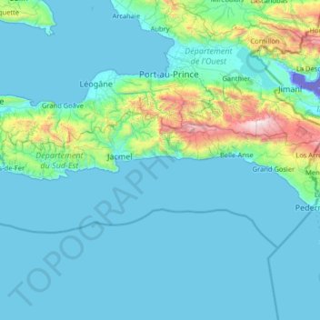
Name: South-East topographic map, elevation, terrain.
Location: South-East, Haiti (18.03150 -73.01559 18.40560 -71.72493)
Average elevation: 234 m
Minimum elevation: -43 m
Maximum elevation: 2,627 m
Make a donation
Gear up for your next adventure:
As an Amazon Associate, this site earns from qualifying purchases at no extra cost to you.
Other topographic maps
Click on a map to view its topography, its elevation and its terrain.
Simonette
Haiti > Artibonite Department > Commune Petite Rivière de l'Artibonite
Average elevation: 574 m
Make a donation
Gear up for your next adventure:
As an Amazon Associate, this site earns from qualifying purchases at no extra cost to you.
Make a donation
Gear up for your next adventure:
As an Amazon Associate, this site earns from qualifying purchases at no extra cost to you.
Breton
Haiti > Département de la Grande-Anse > Commune Dame-Marie > Dame Marie > Breton
Average elevation: 48 m
Saint-Louis-du-Nord
Haiti > Nord-Ouest Department > Commune Saint-Louis du Nord
Average elevation: 65 m
Make a donation
Gear up for your next adventure:
As an Amazon Associate, this site earns from qualifying purchases at no extra cost to you.