

Sud Department topographic map
Click on the map to display elevation.
About this map
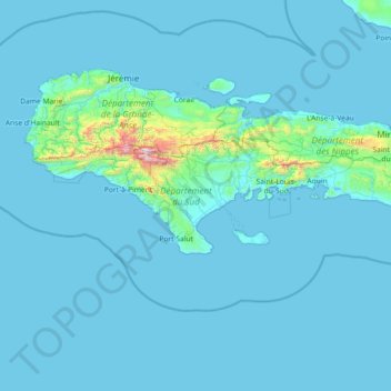
Name: Sud Department topographic map, elevation, terrain.
Location: Sud Department, Haiti (18.02062 -74.45203 18.43324 -73.00121)
Average elevation: 81 m
Minimum elevation: -1 m
Maximum elevation: 2,301 m
Other topographic maps
Click on a map to view its topography, its elevation and its terrain.
Caribbean
Rainfall varies with elevation, size and water currents, such as the cool upwellings that keep the ABC islands arid. Warm, moist trade winds blow consistently from the east, creating both rain forest and semi arid climates across the region. The tropical rainforest climates include lowland areas near the…
Average elevation: 20 m
Caribbean
Rainfall varies with elevation, size and water currents, such as the cool upwellings that keep the ABC islands arid. Warm, moist trade winds blow consistently from the east, creating both rain forest and semi arid climates across the region. The tropical rainforest climates include lowland areas near the…
Average elevation: 20 m

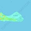
Île-à-Vache
Haiti > Sud Department > Commune Île-à-Vache
The island is about 8 miles (13 km) long and 2 miles (3.2 km) wide, with an area of 20 square miles (52 km2). The western end of the island has rolling hills with elevations as high as 490 feet (150 m) with several small swamps in the valleys; the eastern side of the island is swampy, and contains a lagoon…
Average elevation: 2 m



Pic la Selle
Haiti > West > Commune Croix-des-Bouquets
A forest of pine trees is present above the elevation of 1,800 metres (5,900 ft). Celestus macrotus is present on the northeastern slopes of Pic la Selle. A report in the 1930s listed white-winged warblers, and eastern chat-tanagers, and Antillean siskins as being present on the mountain. A breeding colony of…
Average elevation: 2,364 m
Caribbean
Rainfall varies with elevation, size and water currents, such as the cool upwellings that keep the ABC islands arid. Warm, moist trade winds blow consistently from the east, creating both rain forest and semi arid climates across the region. The tropical rainforest climates include lowland areas near the…
Average elevation: 20 m
Port-au-Prince
Haiti > West > Port-au-Prince
By then, the colonial administration was convinced that a capital needed to be chosen, in order to better control the French portion of Hispaniola (Saint-Domingue). For a time, Petit-Goâve and Léogâne vied for this honor, but both were eventually ruled out for various reasons. Neither was centrally located.…
Average elevation: 376 m


Île-à-Vache
Haiti > Sud Department > Commune Île-à-Vache
The island is about 8 miles (13 km) long and 2 miles (3.2 km) wide, with an area of 20 square miles (52 km2). The western end of the island has rolling hills with elevations as high as 490 feet (150 m) with several small swamps in the valleys; the eastern side of the island is swampy, and contains a lagoon…
Average elevation: 2 m







Île de la Navasse / Navassa Island
Navassa reaches an elevation of 250 feet (76 m) at Dunning Hill 110 yards (100 m) south of the lighthouse, Navassa Island Light. This location is 440 yards (400 m) from the southwestern coast or 655 yards (600 m) east of Lulu Bay.
Average elevation: 28 m

Petite-Rivière-de-l'Artibonite
Haiti > Artibonite Department > Commune Petite Rivière de l'Artibonite
Average elevation: 51 m






Ravine Nan Gola
Haiti > Nord-Ouest Department > Commune Jean Rabel > Jean-Rabel
Average elevation: 188 m
Petite-Rivière-de-l'Artibonite
Haiti > Artibonite Department > Commune Petite Rivière de l'Artibonite
Average elevation: 51 m



Caracol
Haiti > Nord-Est Department > Commune Caracol > Caracol
Caracol is a large ancient Maya archaeological site, located in what is now the Cayo District, of Belize. It is situated approximately 40 kilometres (25 mi) south of Xunantunich, and the town of San Ignacio, and 15 km (9.3 mi) from the Macal River. It rests on the Vaca Plateau, at an elevation of 500 m (1,600…
Average elevation: 7 m

Caribbean
Rainfall varies with elevation, size and water currents, such as the cool upwellings that keep the ABC islands arid. Warm, moist trade winds blow consistently from the east, creating both rain forest and semi arid climates across the region. The tropical rainforest climates include lowland areas near the…
Average elevation: 20 m