
Arrondissement Gros Morne topographic map
Interactive map
Click on the map to display elevation.
About this map
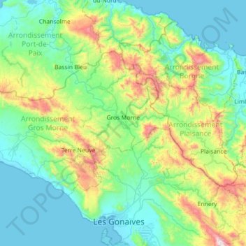
Name: Arrondissement Gros Morne topographic map, elevation, terrain.
Location: Arrondissement Gros Morne, Artibonite Department, Haiti (19.50104 -73.13629 19.81558 -72.57082)
Average elevation: 308 m
Minimum elevation: -1 m
Maximum elevation: 1,467 m
Other topographic maps
Click on a map to view its topography, its elevation and its terrain.
Simonette
Haiti > Artibonite Department > Commune Petite Rivière de l'Artibonite
Simonette, 6ème Médor, Commune Petite Rivière de l'Artibonite, Arrondissement de Dessalines, Artibonite Department, Haiti
Average elevation: 574 m
Duclos
Haiti > Artibonite Department > Commune Desdunes
Duclos, Commune Desdunes, Arrondissement de Dessalines, Artibonite Department, Haiti
Average elevation: 5 m
Terre Neuve
Terre Neuve, Arrondissement Gros Morne, Artibonite Department, Haiti
Average elevation: 638 m
Commune de Saint-Marc
Haiti > Artibonite Department > Commune de Saint-Marc
Commune de Saint-Marc, Arrondissement de Saint-Marc, Artibonite Department, Haiti
Average elevation: 238 m
2e Bois Neuf
Haiti > Artibonite Department > Commune de Saint-Marc
2e Bois Neuf, Commune de Saint-Marc, Arrondissement de Saint-Marc, Artibonite Department, Haiti
Average elevation: 141 m
sainte anne
Haiti > Artibonite Department > sainte anne
sainte anne, Arrondissement des Gonaïves, Artibonite Department, Haiti
Average elevation: 343 m