
Budapest topographic map
Interactive map
Click on the map to display elevation.
Budapest
The wide Danube was always fordable at this point because of a small number of islands in the middle of the river. The city has marked topographical contrasts: Buda is built on the higher river terraces and hills of the western side, while the considerably larger Pest spreads out on a flat and featureless sand plain on the river's opposite bank. Pest's terrain rises with a slight eastward gradient, so the easternmost parts of the city lie at the same altitude as Buda's smallest hills, notably Gellért Hill and Castle Hill.
About this map
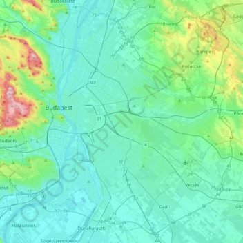
Name: Budapest topographic map, elevation, terrain.
Location: Budapest, Central Hungary, Hungary (47.34969 18.92511 47.61315 19.33493)
Average elevation: 153 m
Minimum elevation: 89 m
Maximum elevation: 512 m
Other topographic maps
Click on a map to view its topography, its elevation and its terrain.
Pannonian Basin
Pannonian basin vs Carpathian basin: On the territory of present-day Hungary the ancient Roman Pannonia province was located only on Transdanubian territories, however the Great Hungarian Plain was not part of Pannonia province. This comprises less than 29% of modern Hungary, therefore Hungarian geographers…
Average elevation: 99 m
Kékes
Kékes Peak is the highest altitude region in Hungary, so it has the highest altitude weather station in the country. Although the mountain is still classified as a temperate humid continental climate (Dfb) according to the Köppen climate classification, it is very close to a subarctic climate (Dfc). Unlike…
Average elevation: 817 m
Pécs
Pécs is bordered by plains to the south (elevation 120–130 m), while the Mecsek mountains rise up to elevations of 400–600 meters behind the city. Jakab-hill, located in the western Mecsek, is 592 m (1942 ft) tall, Tubes, straight above Pécs, is 612 m (2008 ft) tall, and Misina is 535 m (1755 ft) tall.…
Average elevation: 210 m
Szentistvánbaksa
Hungary > Borsod-Abaúj-Zemplén > Szentistvánbaksa > Szentistvánbaksa
Average elevation: 163 m