Geolocate

Mátra topographic map

Click on the map to display elevation.

About this map

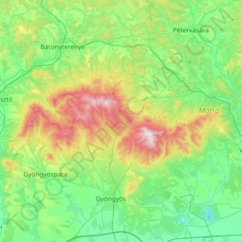
Name: Mátra topographic map, elevation, terrain.

Location: Mátra, Heves, Northern Hungary, Great Plain and North, Hungary (47.77474 19.68986 48.00584 20.20079)

Average elevation: 285 m

Minimum elevation: 38 m

Maximum elevation: 1,015 m

Other topographic maps

Click on a map to view its topography, its elevation and its terrain.

Visonta

Hungary > Heves

Average elevation: 185 m

Eger

Hungary > Heves > Eger

Average elevation: 244 m

Gear up for your next adventure:

🚑Survival Whistle - Signal for help across long distances in mountains
🧥Fleece Jacket - Warm and lightweight jacket for layering
🕶️Polarized Sunglasses - Protect your eyes with durable polarized lenses
🧥Softshell Hiking Jacket - The perfect balance of wind protection and breathability
🛏️Camping Sleeping Mat - Comfortable mats for sleeping outdoors

As an Amazon Associate, this site earns from qualifying purchases at no extra cost to you.