
Vorarlberg topographic map
Interactive map
Click on the map to display elevation.
Vorarlberg
The highest mountain is the Piz Buin, whose rocky peak of 3,312 m (10,866 ft) is surrounded by glaciers. The distance from Lake Constance and the plains of the Alpine Rhine valley across the medium altitude and high Alpine zones to the glaciers of the Silvretta range is a mere 90 km (56 mi).
About this map
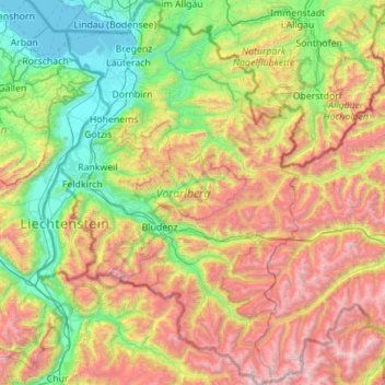
Name: Vorarlberg topographic map, elevation, terrain.
Location: Vorarlberg, Austria (46.84086 9.53075 47.59610 10.23716)
Average elevation: 1,382 m
Minimum elevation: 392 m
Maximum elevation: 3,386 m
Other topographic maps
Click on a map to view its topography, its elevation and its terrain.
Lahnberg
Austria > Lower Austria > Bezirk Neunkirchen > Schwarzau im Gebirge
Average elevation: 1,213 m
Klagenfurt Land
Austria > Carinthia > Bezirk Klagenfurt-Land > Krumpendorf am Wörthersee
Average elevation: 894 m
Bad Eisenkappel/Železna Kapla
Austria > Carinthia > Bezirk Völkermarkt > Eisenkappel-Vellach
Average elevation: 914 m