
Clare County topographic map
Interactive map
Click on the map to display elevation.
About this map
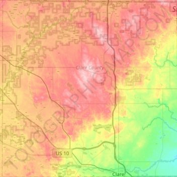
Name: Clare County topographic map, elevation, terrain.
Location: Clare County, Michigan, United States (43.81361 -85.08881 44.16425 -84.60604)
Average elevation: 321 m
Minimum elevation: 225 m
Maximum elevation: 417 m
Other topographic maps
Click on a map to view its topography, its elevation and its terrain.
Grand Island
United States > Michigan > Presque Isle County > Presque Isle Township
Average elevation: 182 m
Muskegon River - South Channel
United States > Michigan > Muskegon County > Muskegon
Average elevation: 188 m
Grand Mere State Park
United States > Michigan > Berrien County > Stevensville
Average elevation: 185 m
Dean Lake
United States > Michigan > Kent County > Plainfield Charter Township
Average elevation: 228 m
Oakley Park
United States > Michigan > Oakland County > Commerce Charter Township
Average elevation: 282 m
South Gull Lake
United States > Michigan > Kalamazoo County > South Gull Lake
Average elevation: 274 m
Christmas
United States > Michigan > Alger County > Au Train Township > Christmas
Average elevation: 203 m
North Branch Marsh Drain
United States > Michigan > Washtenaw County > Augusta Township
Average elevation: 206 m