Geolocate

Saint Mary's County topographic map

Interactive map

Click on the map to display elevation.

About this map

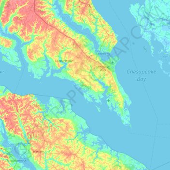
Name: Saint Mary's County topographic map, elevation, terrain.

Location: Saint Mary's County, Maryland, United States (37.89031 -76.87435 38.51371 -76.19967)

Average elevation: 13 m

Minimum elevation: -4 m

Maximum elevation: 62 m

Other topographic maps

Click on a map to view its topography, its elevation and its terrain.

Howard County

United States > Maryland

Howard County, Maryland, United States

Average elevation: 128 m

Hyattsville

United States > Maryland > Prince George's County

Hyattsville, Prince George's County, Maryland, 20781, United States

Average elevation: 61 m

High Point

United States > Maryland > Anne Arundel County > Pasadena

High Point, Pasadena, Anne Arundel County, Maryland, 21122, United States

Average elevation: 12 m

Kingsville

United States > Maryland > Baltimore County

Kingsville, Baltimore County, Maryland, 21087, United States

Average elevation: 83 m

Springwood

United States > Maryland > Anne Arundel County > Jessup

Springwood, Jessup, Anne Arundel County, Maryland, 20794, United States

Average elevation: 63 m

Elkridge

United States > Maryland > Howard County

Elkridge, Howard County, Maryland, 21075, United States

Average elevation: 39 m

Turkey Point Park

United States > Maryland > Baltimore County > Dundalk > Turkey Point

Turkey Point Park, Bauernschmidt Manor, Turkey Point, Dundalk, Baltimore County, Maryland, United States

Average elevation: 2 m

Ellicott City

United States > Maryland > Howard County

Ellicott City, Howard County, Maryland, 21043, United States

Average elevation: 119 m

Fairland

United States > Maryland > Montgomery County

Fairland, Montgomery County, Maryland, United States

Average elevation: 111 m

Dundalk

United States > Maryland > Baltimore County

Dundalk, Baltimore County, Maryland, 21222, United States

Average elevation: 33 m

Benfield

United States > Maryland > Anne Arundel County > Glen Burnie

Benfield, Glen Burnie, Anne Arundel County, Maryland, 21108, United States

Average elevation: 25 m

Wetipquin

United States > Maryland > Wicomico County

Wetipquin, Wicomico County, Maryland, 21814, United States

Average elevation: 3 m

Salisbury

United States > Maryland > Wicomico County

Salisbury, Wicomico County, Maryland, United States

Average elevation: 12 m

Highland Beach

United States > Maryland > Anne Arundel County

Highland Beach, Anne Arundel County, Maryland, United States

Average elevation: 3 m

Leeds

United States > Maryland > Anne Arundel County

Leeds, Anne Arundel County, Maryland, 21077, United States

Average elevation: 47 m

Germantown

United States > Maryland > Montgomery County

Germantown, Montgomery County, Maryland, 20874, United States

Average elevation: 136 m

Boones Mobile Estates

United States > Maryland > Anne Arundel County

Boones Mobile Estates, Anne Arundel County, Maryland, 20711, United States

Average elevation: 30 m

Druid Hill Park

United States > Maryland > Baltimore

Druid Hill Park, Park Heights, Baltimore, Maryland, United States

Average elevation: 78 m

Bird River

United States > Maryland > Baltimore County > Bowleys Quarters

Bird River, Bowleys Quarters, Baltimore County, Maryland, United States

Average elevation: 4 m

Sugarloaf Mountain

United States > Maryland > Frederick County > Stronghold

Sugarloaf Mountain, 7901, Comus Road, Stronghold, Frederick County, Maryland, 20842, United States

Average elevation: 161 m

Bidle Hill Acres

United States > Maryland > Frederick County

Bidle Hill Acres, Frederick County, Maryland, 21173, United States

Average elevation: 184 m

Altogether

United States > Maryland > Frederick County > Thurmont

Altogether, Thurmont, Frederick County, Maryland, 21788, United States

Average elevation: 231 m

Casselman Bridge State Park

United States > Maryland > Garrett County > Grantsville

Casselman Bridge State Park, Grantsville, Garrett County, Maryland, United States

Average elevation: 696 m

College Park

United States > Maryland > Prince George's County

College Park, Prince George's County, Maryland, United States

Average elevation: 38 m

Crofton

United States > Maryland > Anne Arundel County

Crofton, Anne Arundel County, Maryland, 21114, United States

Average elevation: 35 m

Cambridge

United States > Maryland > Dorchester County

Cambridge, Dorchester County, Maryland, 21613, United States

Average elevation: 3 m

Franklin Manor Beach

United States > Maryland > Anne Arundel County

Franklin Manor Beach, Anne Arundel County, Maryland, 20733, United States

Average elevation: 1 m

North Brentwood

United States > Maryland > Prince George's County

North Brentwood, Prince George's County, Maryland, United States

Average elevation: 15 m

Cottage City

United States > Maryland > Prince George's County

Cottage City, Prince George's County, Maryland, United States

Average elevation: 17 m

Derwood

United States > Maryland > Montgomery County

Derwood, Montgomery County, Maryland, 20855, United States

Average elevation: 133 m

Woodcrest

United States > Maryland > Anne Arundel County > Ferndale

Woodcrest, Ferndale, Anne Arundel County, Maryland, 21062, United States

Average elevation: 28 m

Dinosaur Park

United States > Maryland > Prince George's County > South Laurel > Montpelier Forest

Dinosaur Park, Montpelier Forest, South Laurel, Prince George's County, Maryland, 20708, United States

Average elevation: 67 m

Ammendale

United States > Maryland > Prince George's County > Konterra

Ammendale, Konterra, Prince George's County, Maryland, 20705, United States

Average elevation: 56 m

Chesapeake Forest

United States > Maryland > Somerset County > Upper Hill

Chesapeake Forest, Upper Hill, Somerset County, Maryland, 21867, United States

Average elevation: 1 m

Pylesville

United States > Maryland > Harford County

Pylesville, Harford County, Maryland, 21132, United States

Average elevation: 135 m

Cohill

United States > Maryland > Washington County

Cohill, Washington County, Maryland, 25411, United States

Average elevation: 207 m

Baltimore

United States > Maryland > Baltimore

Baltimore, Maryland, 21203, United States

Average elevation: 65 m

Mason Island

United States > Maryland > Montgomery County

Mason Island, Montgomery County, Maryland, United States

Average elevation: 78 m

Riva

United States > Maryland > Anne Arundel County

Riva, Anne Arundel County, Maryland, 21041, United States

Average elevation: 11 m

Timonium

United States > Maryland > Baltimore County

Timonium, Baltimore County, Maryland, 21093, United States

Average elevation: 118 m

North Keys

United States > Maryland > Prince George's County

North Keys, Prince George's County, Maryland, United States

Average elevation: 43 m

Randolph Hills

United States > Maryland > Montgomery County > North Bethesda

Randolph Hills, North Bethesda, Montgomery County, Maryland, 20896, United States

Average elevation: 98 m

Grantsville

United States > Maryland > Garrett County

Grantsville, Garrett County, Maryland, United States

Average elevation: 706 m

Pasadena Beach

United States > Maryland > Anne Arundel County

Pasadena Beach, Anne Arundel County, Maryland, United States

Average elevation: 4 m

Crownsville

United States > Maryland > Anne Arundel County > Crownsville

Crownsville, Anne Arundel County, Maryland, 21140, United States

Average elevation: 30 m

Landover

United States > Maryland > Prince George's County > Landover

Landover, Prince George's County, Maryland, 20785, United States

Average elevation: 38 m

White Oak

United States > Maryland > Montgomery County > White Oak

White Oak, Montgomery County, Maryland, 20993, United States

Average elevation: 101 m

Middle East

United States > Maryland > Baltimore

Middle East, Baltimore, Maryland, United States

Average elevation: 29 m

Green Haven

United States > Maryland > Anne Arundel County > Pasadena

Green Haven, Pasadena, Anne Arundel County, Maryland, 21122, United States

Average elevation: 15 m

Washington County

United States > Maryland

Washington County, Maryland, United States

Average elevation: 195 m