
Monrovia topographic map
Click on the map to display elevation.
About this map
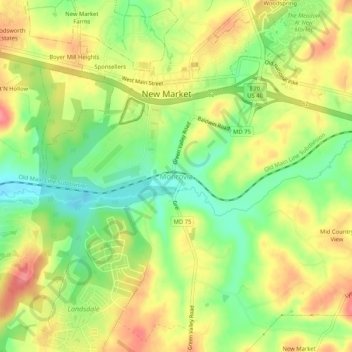
Name: Monrovia topographic map, elevation, terrain.
Location: Monrovia, Frederick County, Maryland, 21174, United States (39.35205 -77.29193 39.39205 -77.25193)
Average elevation: 153 m
Minimum elevation: 114 m
Maximum elevation: 190 m
Other topographic maps
Click on a map to view its topography, its elevation and its terrain.
Catoctin Mountain Park
United States > Maryland > Frederick County > Thurmont
Average elevation: 422 m