
Make a donation
Gear up for your next adventure:
As an Amazon Associate, this site earns from qualifying purchases at no extra cost to you.
Sunset Beach topographic map
Click on the map to display elevation.
Make a donation
Gear up for your next adventure:
As an Amazon Associate, this site earns from qualifying purchases at no extra cost to you.
About this map
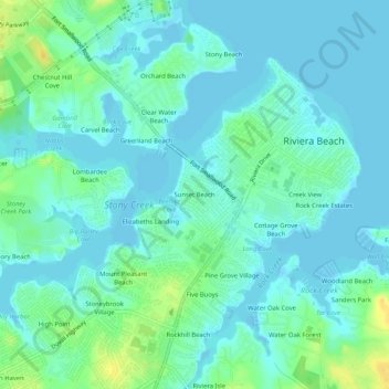
Name: Sunset Beach topographic map, elevation, terrain.
Average elevation: 7 m
Minimum elevation: -2 m
Maximum elevation: 25 m
Make a donation
Gear up for your next adventure:
As an Amazon Associate, this site earns from qualifying purchases at no extra cost to you.
Other topographic maps
Click on a map to view its topography, its elevation and its terrain.
Patapsco River
United States > Maryland > Anne Arundel County > Riviera Beach
The Patapsco River mainstem begins at the confluence of the North and South Branches, near Marriottsville, approximately 15 miles (24 km) west of downtown Baltimore. The 19.4-mile-long (31.2 km)[1] South Branch rises further west at Parr's Spring, where Howard County, Carroll, Frederick, and Montgomery…
Average elevation: 7 m