
California topographic map
Click on the map to display elevation.
About this map
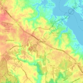
Name: California topographic map, elevation, terrain.
Average elevation: 25 m
Minimum elevation: -2 m
Maximum elevation: 48 m
Other topographic maps
Click on a map to view its topography, its elevation and its terrain.
Mechanicsville
United States > Maryland > Saint Mary's County > Mechanicsville
Average elevation: 46 m
St. George Island
United States > Maryland > Saint Mary's County > Piney Point > Saint George Island
Average elevation: 0 m
Charlotte Hall
United States > Maryland > Saint Mary's County > Charlotte Hall
Average elevation: 49 m
Lexington Park
United States > Maryland > Saint Mary's County > Lexington Park
Average elevation: 24 m
Lexington Park
United States > Maryland > Saint Mary's County > Lexington Park
Average elevation: 24 m
Mechanicsville
United States > Maryland > Saint Mary's County > Mechanicsville
Average elevation: 46 m
Lexington Park
United States > Maryland > Saint Mary's County > Lexington Park
Average elevation: 24 m