Geolocate

Towson topographic map

Click on the map to display elevation.

About this map

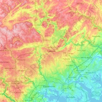
Name: Towson topographic map, elevation, terrain.

Location: Towson, Baltimore County, Maryland, 21252, United States (39.24185 -76.76238 39.56185 -76.44238)

Average elevation: 101 m

Minimum elevation: -3 m

Maximum elevation: 225 m

Other topographic maps

Click on a map to view its topography, its elevation and its terrain.

Arbutus

United States > Maryland > Baltimore County > Relay

Average elevation: 42 m

Parkville

United States > Maryland > Baltimore County > Parkville

Average elevation: 111 m

Hampton

United States > Maryland > Baltimore County > Hampton

Average elevation: 108 m

Essex

United States > Maryland > Baltimore County > Essex

Average elevation: 6 m

Dundalk

United States > Maryland > Baltimore County > Dundalk

Average elevation: 6 m

Gear up for your next adventure:

🥾Trail Hiking Shoes - Durable shoes designed for rugged trails
🧦Merino Wool Socks - Moisture-wicking comfort for long-distance hiking
🧢Outdoor Visor - Breathable visor for sunny hikes
🧼Biodegradable Camp Soap - Environmentally friendly cleaning for gear and body
🔋Emergency Crank Radio - Weather alerts and power without needing batteries

As an Amazon Associate, this site earns from qualifying purchases at no extra cost to you.