
Marysville topographic map
Interactive map
Click on the map to display elevation.
About this map
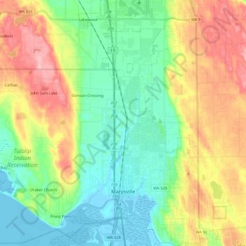
Name: Marysville topographic map, elevation, terrain.
Location: Marysville, Snohomish County, Washington, United States (48.01984 -122.28651 48.16329 -122.10961)
Average elevation: 72 m
Minimum elevation: -3 m
Maximum elevation: 201 m
The city's topography varies from the low-lying downtown, located along the banks of Ebey Slough 5 feet (1.5 m) above sea level, rising to 160 feet (49 m) near Smokey Point and over 465 feet (142 m) in the eastern highlands. Marysville sits in the watershed of two major creeks, Quilceda Creek and Allen Creek, and approximately 70 minor streams that flow into Ebey Slough and Snohomish River. During the early 20th century, repeated controlled flooding and other engineering works in the Snohomish River delta contributed to the replenishment of the area's fertile silty soil for use in farming.
Other topographic maps
Click on a map to view its topography, its elevation and its terrain.
Index
United States > Washington > Snohomish County
Index, Snohomish County, Washington, United States
Average elevation: 366 m
Tomtit Lake
United States > Washington > Snohomish County
Tomtit Lake, Snohomish County, Washington, United States
Average elevation: 272 m
Sultan
United States > Washington > Snohomish County
Sultan, Snohomish County, Washington, 98294, United States
Average elevation: 78 m
Mill Creek
United States > Washington > Snohomish County
Mill Creek, Snohomish County, Washington, United States
Average elevation: 130 m
Sulphur Mountain
United States > Washington > Snohomish County
Sulphur Mountain, Snohomish County, Washington, United States
Average elevation: 1,628 m
Pass Lake
United States > Washington > Snohomish County
Pass Lake, Snohomish County, Washington, United States
Average elevation: 1,167 m
Edmonds
United States > Washington > Snohomish County
Edmonds, Snohomish County, Washington, United States
Average elevation: 44 m
Lake Ketchum
United States > Washington > Snohomish County > Lake Ketchum
Lake Ketchum, Snohomish County, Washington, United States
Average elevation: 56 m
Monroe
United States > Washington > Snohomish County
Monroe, Snohomish County, Washington, 98272, United States
Average elevation: 49 m
Everett
United States > Washington > Snohomish County
Everett, Snohomish County, Washington, United States
Average elevation: 69 m
Glacier Peak
United States > Washington > Snohomish County
Glacier Peak, Snohomish County, Washington, United States
Average elevation: 2,656 m
Darrington
United States > Washington > Snohomish County
Darrington, Snohomish County, Washington, United States
Average elevation: 190 m