
Make a donation
Gear up for your next adventure:
As an Amazon Associate, this site earns from qualifying purchases at no extra cost to you.
Monroe topographic map
Click on the map to display elevation.
Make a donation
Gear up for your next adventure:
As an Amazon Associate, this site earns from qualifying purchases at no extra cost to you.
Monroe
The city lies at the eastern end of the Snohomish River floodplain, with elevations that range from 40 to 210 feet (12 to 64 m). The south and east edges of the city along the Skykomish River are within a 100-year flood hazard zone and also include habitats for migratory birds and game animals. The residential neighborhoods of Monroe lie within the watersheds of French Creek and Woods Creek, which both drain into the Skykomish River before its confluence with the Snoqualmie and Snohomish rivers. The surrounding area includes hills and plateaus that were formed from glacial till and gravel deposits from the Skykomish River. Monroe also sits on a local fault line that produced a pair of minor earthquakes on July 12, 2019, that were felt as far as Seattle and Vancouver without causing damage.
Make a donation
Gear up for your next adventure:
As an Amazon Associate, this site earns from qualifying purchases at no extra cost to you.
About this map
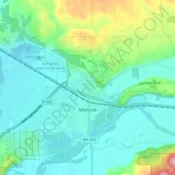
Name: Monroe topographic map, elevation, terrain.
Location: Monroe, Snohomish County, Washington, 98272, United States (47.83759 -122.01268 47.88630 -121.93306)
Average elevation: 49 m
Minimum elevation: 3 m
Maximum elevation: 211 m
Make a donation
Gear up for your next adventure:
As an Amazon Associate, this site earns from qualifying purchases at no extra cost to you.
Other topographic maps
Click on a map to view its topography, its elevation and its terrain.