
Anantnag topographic map
Interactive map
Click on the map to display elevation.
About this map
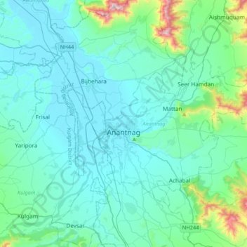
Name: Anantnag topographic map, elevation, terrain.
Location: Anantnag, Jammu and Kashmir, India (33.65607 75.11172 33.83642 75.43741)
Average elevation: 1,790 m
Minimum elevation: 1,589 m
Maximum elevation: 3,105 m
Other topographic maps
Click on a map to view its topography, its elevation and its terrain.
Rajouri
India > Jammu and Kashmir > Rajauri
Rajouri is located at 33°23′N 74°18′E / 33.38°N 74.3°E / 33.38; 74.3. It has an average elevation of 915 metres (3001 feet).
Average elevation: 1,038 m
Nowshera
India > Jammu and Kashmir > Nowshehra Tehsil
Given its spatial and demographic extent, Nowshera has been given the status of a Sub-District. It is a beautiful place with a number of tourist attractions including the fort of Mangla Devi, holy cave temple of Mangla Mata, Central Gurudwara of Sikhs in Nonial, Qila Darhal and other Dargahs and temples. The…
Average elevation: 668 m
Katra
India > Jammu and Kashmir > Reasi > Katra
Katra is located at 32°59′N 74°57′E / 32.98°N 74.95°E / 32.98; 74.95. It has an average elevation of 875 metres (2,474 feet). The Banganga River passes through the village.
Average elevation: 993 m