
Western Bahr el Ghazal topographic map
Interactive map
Click on the map to display elevation.
About this map
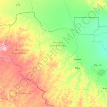
Name: Western Bahr el Ghazal topographic map, elevation, terrain.
Location: Western Bahr el Ghazal, South Sudan (6.64984 23.44778 10.43900 28.53616)
Average elevation: 596 m
Minimum elevation: 409 m
Maximum elevation: 1,303 m
Other topographic maps
Click on a map to view its topography, its elevation and its terrain.
Awoda
South Sudan > Northern Bahr el Ghazal > Aweil Centre
Awoda, Aweil Centre, Northern Bahr el Ghazal, South Sudan
Average elevation: 571 m
Nahr al Jur
South Sudan > Western Bahr el Ghazal
Nahr al Jur, Western Bahr el Ghazal, South Sudan
Average elevation: 546 m
White Nile
South Sudan > Upper Nile > Malakal
White Nile, Malakal, Upper Nile, South Sudan
Average elevation: 393 m