
Unity topographic map
Interactive map
Click on the map to display elevation.
About this map
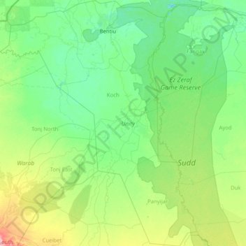
Name: Unity topographic map, elevation, terrain.
Location: Unity, South Sudan (7.06721 28.69818 9.55788 30.71205)
Average elevation: 401 m
Minimum elevation: 388 m
Maximum elevation: 492 m
Other topographic maps
Click on a map to view its topography, its elevation and its terrain.
Awoda
South Sudan > Northern Bahr el Ghazal > Aweil Centre
Awoda, Aweil Centre, Northern Bahr el Ghazal, South Sudan
Average elevation: 571 m
Nahr al Jur
South Sudan > Western Bahr el Ghazal
Nahr al Jur, Western Bahr el Ghazal, South Sudan
Average elevation: 546 m
White Nile
South Sudan > Upper Nile > Malakal
White Nile, Malakal, Upper Nile, South Sudan
Average elevation: 393 m