
Mackenzie topographic map
Interactive map
Click on the map to display elevation.
About this map
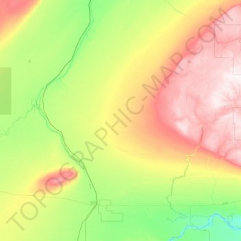
Name: Mackenzie topographic map, elevation, terrain.
Location: Mackenzie, Alberta, Canada (58.32329 -117.50865 59.60329 -116.22865)
Average elevation: 458 m
Minimum elevation: 244 m
Maximum elevation: 996 m
Alberta trails, hiking, mountain biking, running and outdoor activities
Other topographic maps
Click on a map to view its topography, its elevation and its terrain.
Calgary
Calgary experiences a semi-monsoonal humid continental climate (Köppen climate classification Dwb) within eastern parts of the city and a subarctic climate (Köppen climate classification Dwc) within western parts of the city due to an increase in elevation. The city has warm, comfortable summers and…
Average elevation: 1,106 m
Edmonton
Edmonton is on the North Saskatchewan River, at an elevation of 671 m (2,201 ft). It is North America's northernmost city with a metropolitan population over one million. It is at the same latitude as Hamburg (Germany); Dublin (Ireland); Manchester (United Kingdom); and Magnitogorsk (Russia). It is south of…
Average elevation: 690 m
Nose Hill Park
Names currently associated with topographical features in and near Nose Hill Park reflect the impact of the European newcomers and European trade goods on the Peigan. For example, Spy Hill, the westward extension of Nose Hill, derived its present name from the aboriginal practice of communicating with distant…
Average elevation: 1,174 m
Fort McMurray
Canada > Alberta > Wood Buffalo
The community lies at a lower elevation than most other parts of Alberta, so under the right conditions it can be a "hot spot" for Alberta.
Average elevation: 345 m
Town of Fox Creek
Fox Creek is a town in northwest Alberta, Canada. It is located on Highway 43, approximately 259 km (161 mi) northwest of Edmonton and 199 km (124 mi) southeast of Grande Prairie, and has an elevation of 808 m (2,651 ft).
Average elevation: 824 m
Waterton Lakes National Park
Canada > Alberta > Division No. 3
Operated by Parks Canada, Waterton is open all year, but the main tourist season is during July and August. The only commercial facilities available within the park are located at the Waterton Park townsite. This park ranges in elevation from 1,290 metres (4,232 ft) at the townsite to 2,910 m (9,547 ft) at…
Average elevation: 1,778 m
Town of Cochrane
Cochrane is situated at the base of Big Hill in the Bow River Valley. It sits at an elevation of 1,186 m (3,891 ft). The town is intersected by Highway 1A and Highway 22. Cochrane has a reputation for its western culture—clearly seen when one wanders the streets (particularly First St). The town is a popular…
Average elevation: 1,200 m
Redcliff
Situated at a high elevation relative to the surrounding landscape, the Town of Redcliff offers views of the South Saskatchewan River valley, the City of Medicine Hat, and Cypress Hills. The cliffs that overlook the river valley resemble badland formations.
Average elevation: 727 m
Rocky Mountain House
Canada > Alberta > Rocky Mountain House
Rocky Mountain House has a subarctic climate (Köppen climate classification Dfc) that borders on a humid continental climate (Köppen Dfb). Daytime temperatures are in general representative for the latter, but the larger diurnal temperature variation with the high elevation ensures frequent frosts. The…
Average elevation: 988 m
Fort McKay
Canada > Alberta > Wood Buffalo
Fort McKay (/məˈkaɪ/ mə-KY) or Fort MacKay is a community in northeast Alberta, Canada, located at the confluence of the Athabasca and MacKay rivers. It is approximately 54 km (34 mi) north of Fort McMurray via Highway 63 and Fort McKay Road. The community has an elevation of 260 m (850 ft).
Average elevation: 259 m
Town of Fox Creek
Fox Creek is a town in northwest Alberta, Canada. It is located on Highway 43, approximately 259 km (161 mi) northwest of Edmonton and 199 km (124 mi) southeast of Grande Prairie, and has an elevation of 808 m (2,651 ft).
Average elevation: 827 m
Town of Barrhead
The area contains dense stands of spruce, birch, pine and poplar. It also has some of the most fertile farmland in the province and is located between two major rivers, the Athabasca River and Pembina River. The Paddle River, a tributary of the Pembina River, flows directly through the town Barrhead. If you go…
Average elevation: 652 m
Beehive Natural Area
Canada > Alberta > Municipal District of Ranchland No. 66 > Area A (Upper Flathead/Elk Valley)
Average elevation: 2,102 m
Town of Barrhead
The area contains dense stands of spruce, birch, pine and poplar. It also has some of the most fertile farmland in the province and is located between two major rivers, the Athabasca River and Pembina River. The Paddle River, a tributary of the Pembina River, flows directly through the town Barrhead. If you go…
Average elevation: 652 m
Calgary
Calgary experiences a semi-monsoonal humid continental climate (Köppen climate classification Dwb) within eastern parts of the city and a subarctic climate (Köppen climate classification Dwc) within western parts of the city due to an increase in elevation. The city has warm, comfortable summers and…
Average elevation: 1,106 m