
Luwu Utara topographic map
Click on the map to display elevation.
About this map
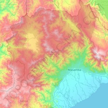
Name: Luwu Utara topographic map, elevation, terrain.
Location: Luwu Utara, South Sulawesi, Sulawesi, Indonesia (-2.91653 119.67626 -1.89064 120.65480)
Average elevation: 1,159 m
Minimum elevation: 0 m
Maximum elevation: 2,985 m
Other topographic maps
Click on a map to view its topography, its elevation and its terrain.