Geolocate

Sapan topographic map

Click on the map to display elevation.

About this map

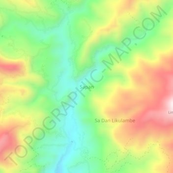
Name: Sapan topographic map, elevation, terrain.

Location: Sapan, Toraja Utara, South Sulawesi, Sulawesi, Indonesia (-2.83292 119.83740 -2.79292 119.87740)

Average elevation: 1,751 m

Minimum elevation: 1,478 m

Maximum elevation: 2,118 m

Gear up for your next adventure:

🦯Trekking Poles - Reduced impact on joints for steep topographic climbs
🧦Thermal Socks - Warm socks for winter hiking or camping
🧤Rechargeable Heated Gloves - Extreme warmth for Canadian winter expeditions
🗺️Topographic Maps - Detailed maps to explore trails, mountains, and wilderness areas
🥾Trail Hiking Shoes - Durable shoes designed for rugged trails

As an Amazon Associate, this site earns from qualifying purchases at no extra cost to you.