
Make a donation
Gear up for your next adventure:
As an Amazon Associate, this site earns from qualifying purchases at no extra cost to you.
Schlitters topographic map
Click on the map to display elevation.
Make a donation
Gear up for your next adventure:
As an Amazon Associate, this site earns from qualifying purchases at no extra cost to you.
Schlitters
Die komplette Liste der Statistik Austria ist in: Topographische Siedlungskennzeichnung nach STAT
Make a donation
Gear up for your next adventure:
As an Amazon Associate, this site earns from qualifying purchases at no extra cost to you.
About this map
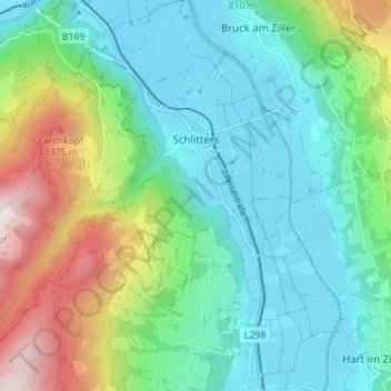
Name: Schlitters topographic map, elevation, terrain.
Location: Schlitters, Bezirk Schwaz, Tirol, 6262, Österreich (47.34703 11.78843 47.39374 11.85753)
Average elevation: 814 m
Minimum elevation: 520 m
Maximum elevation: 1,622 m
Make a donation
Gear up for your next adventure:
As an Amazon Associate, this site earns from qualifying purchases at no extra cost to you.
Other topographic maps
Click on a map to view its topography, its elevation and its terrain.
Make a donation
Gear up for your next adventure:
As an Amazon Associate, this site earns from qualifying purchases at no extra cost to you.
Strass im Zillertal
Österreich > Tirol > Bezirk Schwaz > Gemeinde Strass im Zillertal
Average elevation: 638 m
Make a donation
Gear up for your next adventure:
As an Amazon Associate, this site earns from qualifying purchases at no extra cost to you.
Gedrechter
Österreich > Tirol > Bezirk Schwaz > Gemeinde Kaltenbach
Die Berghänge des Gedrechter bilden während der Wintersaison den nordöstlichsten Teil des Schigebietes Hochfügen-Hochzillertal. In den Sommermonaten wird der Berg von mehreren bezeichneten Wanderwegen erschlossen. Von der an der Zillertaler Höhenstraße in 1723 Metern Höhe gelegenen Kaltenbacher…
Average elevation: 1,971 m
Olperer
Österreich > Tirol > Bezirk Schwaz > Gemeinde Tux
Der Olperer hat mit seinem pyramidenförmigen Gipfelaufbau ein markantes Erscheinungsbild. Dadurch und durch seine geografische Dominanz gegenüber seinen Nachbargipfeln ist er ein beliebter Aussichtsberg. Er liegt etwa vier Kilometer Luftlinie nordwestlich der Schlegeisspeicher-Staumauer und sieben Kilometer…
Average elevation: 2,935 m
Make a donation
Gear up for your next adventure:
As an Amazon Associate, this site earns from qualifying purchases at no extra cost to you.
Vorderunnutz
Österreich > Tirol > Bezirk Schwaz > Gemeinde Steinberg am Rofan
Average elevation: 1,627 m
Hollenzen
Österreich > Tirol > Bezirk Schwaz > Marktgemeinde Mayrhofen > Hollenzen
Average elevation: 950 m
Make a donation
Gear up for your next adventure:
As an Amazon Associate, this site earns from qualifying purchases at no extra cost to you.
Distelberg
Österreich > Tirol > Bezirk Schwaz > Gemeinde Aschau im Zillertal
Average elevation: 1,069 m
Make a donation
Gear up for your next adventure:
As an Amazon Associate, this site earns from qualifying purchases at no extra cost to you.
Holzalm
Österreich > Tirol > Bezirk Schwaz > Gemeinde Fügenberg > Hochfügen
Average elevation: 1,860 m