
Make a donation
Gear up for your next adventure:
As an Amazon Associate, this site earns from qualifying purchases at no extra cost to you.
Gedrechter topographic map
Click on the map to display elevation.
Make a donation
Gear up for your next adventure:
As an Amazon Associate, this site earns from qualifying purchases at no extra cost to you.
Gedrechter
Die Berghänge des Gedrechter bilden während der Wintersaison den nordöstlichsten Teil des Schigebietes Hochfügen-Hochzillertal. In den Sommermonaten wird der Berg von mehreren bezeichneten Wanderwegen erschlossen. Von der an der Zillertaler Höhenstraße in 1723 Metern Höhe gelegenen Kaltenbacher Schihütte aus kann der Gipfel des Gedrechter in ca. eineinhalb Stunden Gehzeit erreicht werden.
Make a donation
Gear up for your next adventure:
As an Amazon Associate, this site earns from qualifying purchases at no extra cost to you.
About this map
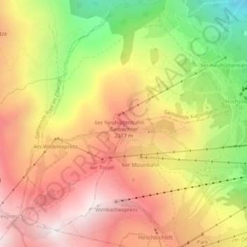
Name: Gedrechter topographic map, elevation, terrain.
Average elevation: 1,971 m
Minimum elevation: 1,382 m
Maximum elevation: 2,423 m
Make a donation
Gear up for your next adventure:
As an Amazon Associate, this site earns from qualifying purchases at no extra cost to you.