
Angels Landing topographic map
Click on the map to display elevation.
Angels Landing
The trail to Angels Landing is 2.5 miles (4.0 km) long with an approximate 1,500 feet (460 m) elevation gain. The hike is rated as a class 3 difficulty based on the Yosemite Decimal System. It begins at the Grotto drop-off point on the park's shuttle system, which operates from early spring through late fall. It roughly follows the path of the Virgin River for some distance along the West Rim Trail, slowly gaining elevation in sandy terrain. Most of the trail is uphill on the way up to Angels Landing. As the trail gets steeper and leaves the river, it becomes paved. After a series of steep switchbacks, the trail goes through the area between Angels Landing and the Zion Canyon that is a gradual ascent. Walter's Wiggles, a series of 21 steep switchbacks, are the last hurdle before Scout Lookout. The wiggles are named after Walter Ruesch, who was the first superintendent for Zion National Park and constructed the switchbacks in 1926.
About this map
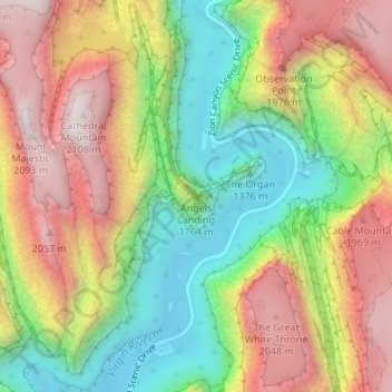
Name: Angels Landing topographic map, elevation, terrain.
Location: Angels Landing, Washington County, Utah, United States (37.26926 -112.94804 37.26936 -112.94794)
Average elevation: 1,695 m
Minimum elevation: 1,303 m
Maximum elevation: 2,116 m
Other topographic maps
Click on a map to view its topography, its elevation and its terrain.
St. George
United States > Utah > Washington County
The St. George valley occasionally receives wet or slushy snowfall in the winter, but what accumulates usually melts off by the mid-to-late morning; the normal seasonal snowfall is 1.4 inches (3.6 cm). The earliest snowfall was measured on October 29, 1971, and the latest on April 11, 1927. The record…
Average elevation: 933 m
Zion National Park
United States > Utah > Washington County
The 8,726-foot (2,660 m) summit of Horse Ranch Mountain is the highest point in the park; the lowest point is the 3,666-foot (1,117 m) elevation of Coal Pits Wash, creating a relief of about 5,100 feet (1,600 m).
Average elevation: 1,877 m
Virgin
United States > Utah > Washington County
Virgin is a town in Washington County, Utah, United States. The population was 670 at the 2020 census. The first settlement at Virgin was made in 1858. It is located along the Virgin River (for which it is named), and not far from Zion National Park. The elevation is 3,606 feet (1,099 m). It lies on State…
Average elevation: 1,251 m
Veyo
United States > Utah > Washington County > Veyo
The elevation of Veyo is 4,485 feet (1,367 m).
Average elevation: 1,379 m
St. George
United States > Utah > Washington County
The St. George valley occasionally receives wet or slushy snowfall in the winter, but what accumulates usually melts off by the mid-to-late morning; the normal seasonal snowfall is 1.4 inches (3.6 cm). The earliest snowfall was measured on October 29, 1971, and the latest on April 11, 1927. The record…
Average elevation: 933 m
Zion National Park
United States > Utah > Washington County
The 8,726-foot (2,660 m) summit of Horse Ranch Mountain is the highest point in the park; the lowest point is the 3,666-foot (1,117 m) elevation of Coal Pits Wash, creating a relief of about 5,100 feet (1,600 m).
Average elevation: 1,877 m
St. George
United States > Utah > Washington County
The St. George valley occasionally receives wet or slushy snowfall in the winter, but what accumulates usually melts off by the mid-to-late morning; the normal seasonal snowfall is 1.4 inches (3.6 cm). The earliest snowfall was measured on October 29, 1971, and the latest on April 11, 1927. The record…
Average elevation: 933 m
St. George
United States > Utah > Washington County
According to the United States Census Bureau, the city has a total area of 77.151 square miles (199.82 km2), of which 0.003 square miles (0.0078 km2) (0.72%) is covered by water. St. George lies in a desert valley, with most of the city lying below 3,000 feet (900 m) in elevation. It is situated near a…
Average elevation: 933 m
Virgin
United States > Utah > Washington County
Virgin is a town in Washington County, Utah, United States. The population was 596 at the 2010 census. The first settlement at Virgin was made in 1858. It is located along the Virgin River (for which it is named), and not far from Zion National Park. The elevation is 3,606 feet (1,099 m). It lies on State…
Average elevation: 1,251 m
Zion National Park
United States > Utah > Washington County
The 8,726-foot (2,660 m) summit of Horse Ranch Mountain is the highest point in the park; the lowest point is the 3,666-foot (1,117 m) elevation of Coal Pits Wash, creating a relief of about 5,100 feet (1,600 m).
Average elevation: 1,877 m
Pine Valley Mountain Wilderness
United States > Utah > Washington County
Pine Valley Mountain Wilderness is a 50,232-acre (203.28 km2) wilderness area located in the Dixie National Forest in the U.S. state of Utah. It is the fourth-largest wilderness area located entirely within the state (following the High Uintas Wilderness, Zion Wilderness, and Cedar Mountain Wilderness). The…
Average elevation: 2,125 m
St. George
United States > Utah > Washington County
The St. George valley occasionally receives wet or slushy snowfall in the winter, but what accumulates usually melts off by the mid-to-late morning; the normal seasonal snowfall is 1.4 inches (3.6 cm). The earliest snowfall was measured on October 29, 1971, and the latest on April 11, 1927. The record…
Average elevation: 929 m
Zion Canyon
United States > Utah > Washington County
Geologically Zion Canyon is part of the Navajo sandstone Colorado Plateau, which contained many joints and cracks when first uplifted, one of which was cut by the North Fork of the Virgin River to become Zion Canyon. The river was the largest force in cutting the canyon, mostly by flash floods, as the average…
Average elevation: 1,821 m
Zion National Park
United States > Utah > Washington County
The 8,726-foot (2,660 m) summit of Horse Ranch Mountain is the highest point in the park; the lowest point is the 3,666-foot (1,117 m) elevation of Coal Pits Wash, creating a relief of about 5,100 feet (1,600 m).
Average elevation: 1,877 m
Virgin
United States > Utah > Washington County
Virgin is a town in Washington County, Utah, United States. The population was 596 at the 2010 census. The first settlement at Virgin was made in 1858. It is located along the Virgin River (for which it is named), and not far from Zion National Park. The elevation is 3,606 feet (1,099 m). It lies on State…
Average elevation: 1,251 m
Cottonwood Canyon Wilderness
United States > Utah > Washington County > Washington
Average elevation: 1,213 m
St. George
United States > Utah > Washington County
According to the United States Census Bureau, the city has an area of 77.151 square miles (199.82 km2), of which 0.003 square miles (0.0078 km2) (0.72% or about 2 ac) is covered by water. St. George is in a desert valley, with most of the city lying below 3,000 feet (900 m) in elevation. It is near a…
Average elevation: 933 m
Zion National Park
United States > Utah > Washington County
The 8,726-foot (2,660 m) summit of Horse Ranch Mountain is the highest point in the park; the lowest point is the 3,666-foot (1,117 m) elevation of Coal Pits Wash, creating a relief of about 5,100 feet (1,600 m).
Average elevation: 1,877 m
St. George
United States > Utah > Washington County
According to the United States Census Bureau, the city has an area of 77.151 square miles (199.82 km2), of which 0.003 square miles (0.0078 km2) (0.72% or about 2 ac) is covered by water. St. George is in a desert valley, with most of the city lying below 3,000 feet (900 m) in elevation. It is near a…
Average elevation: 933 m