Geolocate

Margate topographic map

Click on the map to display elevation.

About this map
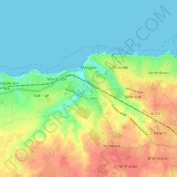
Name: Margate topographic map, elevation, terrain.

Location: Margate, Thanet, Kent, England, United Kingdom (51.36245 1.34033 51.39881 1.43655)

Average elevation: 22 m

Minimum elevation: 0 m

Maximum elevation: 55 m

Other topographic maps

Click on a map to view its topography, its elevation and its terrain.
Broadstairs

United Kingdom > England > Kent > Thanet

Average elevation: 14 m

Minnis Bay

United Kingdom > England > Kent > Thanet

Average elevation: 6 m

Way

United Kingdom > England > Kent > Thanet > Minster > Way

Average elevation: 23 m

Dane Park

United Kingdom > England > Kent > Thanet > Margate

Average elevation: 18 m

Haine

United Kingdom > England > Kent > Thanet > Ramsgate > Westwood

Average elevation: 42 m

Weatherlees Hill

United Kingdom > England > Kent > Thanet > Ebbsfleet

Average elevation: 4 m

Hoo

United Kingdom > England > Kent > Thanet > Minster

Average elevation: 16 m

Pegwell Bay

United Kingdom > England > Kent > Thanet > Cliffsend

Average elevation: 9 m

Flete

United Kingdom > England > Kent > Thanet > Manston

Average elevation: 39 m

Ebbsfleet

United Kingdom > England > Kent > Thanet

Average elevation: 4 m

Birchington

United Kingdom > England > Kent > Thanet

Average elevation: 15 m

Ebbsfleet

United Kingdom > England > Kent > Thanet

Average elevation: 4 m

Broadstairs

United Kingdom > England > Kent > Thanet

Average elevation: 14 m

Gear up for your next adventure:

🛰️Satellite Messenger - Emergency communication for areas with no cell service
🧦Thermal Socks - Warm socks for winter hiking or camping
🧰Emergency Multi-Tool - Compact multi-tool for outdoor survival
🏕️Camping Hammock - Integrated protection for sleeping between trees
🕯️Camping Lantern - Illuminates your entire campsite with high-efficiency LEDs

As an Amazon Associate, this site earns from qualifying purchases at no extra cost to you.