Geolocate

Copley topographic map

Click on the map to display elevation.

About this map

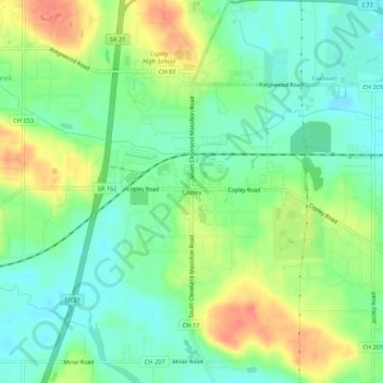
Name: Copley topographic map, elevation, terrain.

Location: Copley, Copley Township, Summit County, Ohio, 44321, United States (41.07894 -81.66457 41.11894 -81.62457)

Average elevation: 318 m

Minimum elevation: 297 m

Maximum elevation: 350 m

Other topographic maps

Click on a map to view its topography, its elevation and its terrain.

Akron

United States > Ohio > Summit County

Akron is situated within the Glaciated Allegheny Plateau, creating a rolling landscape with variable elevations. The city, which lies around 40 miles south of Lake Erie, has an average elevation of approximately 960 feet above sea level, though elevations range from about 700 feet along the Cuyahoga River…

Average elevation: 315 m

Barberton

United States > Ohio > Summit County

Average elevation: 312 m

Stow

United States > Ohio > Summit County

Average elevation: 325 m

Green

United States > Ohio > Summit County

Average elevation: 343 m

New Franklin

United States > Ohio > Summit County

Average elevation: 316 m

Bath Township

United States > Ohio > Summit County

Average elevation: 317 m

Richfield

United States > Ohio > Summit County

Average elevation: 342 m

Richfield Township

United States > Ohio > Summit County

Average elevation: 314 m

Twinsburg

United States > Ohio > Summit County

Average elevation: 321 m

Cuyahoga Falls

United States > Ohio > Summit County

Average elevation: 312 m

Hudson

United States > Ohio > Summit County

Average elevation: 324 m

Tallmadge

United States > Ohio > Summit County

Average elevation: 340 m

Fairlawn

United States > Ohio > Summit County

Average elevation: 311 m

Copley Township

United States > Ohio > Summit County

Average elevation: 317 m

Silver Lake

United States > Ohio > Summit County

Average elevation: 322 m

Boston Township

United States > Ohio > Summit County

Average elevation: 285 m

Cuyahoga Falls

United States > Ohio > Summit County

Average elevation: 312 m

Cuyahoga Falls

United States > Ohio > Summit County

Average elevation: 313 m

Cuyahoga Falls

United States > Ohio > Summit County

Average elevation: 313 m

Barberton

United States > Ohio > Summit County > Barberton

Average elevation: 312 m

Silver Lake

United States > Ohio > Summit County

Average elevation: 322 m

Peninsula

United States > Ohio > Summit County

Average elevation: 259 m

Richfield Township

United States > Ohio > Summit County

Average elevation: 314 m

Portage Lakes

United States > Ohio > Summit County

Average elevation: 308 m

Stow

United States > Ohio > Summit County

Average elevation: 325 m

Akron

United States > Ohio > Summit County

Akron is located in the Great Lakes region about 39 miles (63 km) south of Lake Erie, on the Glaciated Allegheny Plateau. It is bordered by Cuyahoga Falls on the north and Barberton in the southwest. It is the center of the Akron metropolitan area which covers Summit and Portage Counties, and a principal city…

Average elevation: 315 m

Maple Grove Park

United States > Ohio > Summit County > Hudson

Average elevation: 316 m

Norton

United States > Ohio > Summit County

Average elevation: 323 m

Fairlawn

United States > Ohio > Summit County

Average elevation: 311 m

Peninsula

United States > Ohio > Summit County

Average elevation: 259 m

Tallmadge

United States > Ohio > Summit County

Average elevation: 340 m

Hudson

United States > Ohio > Summit County

Average elevation: 324 m

Richfield

United States > Ohio > Summit County > Richfield

Average elevation: 342 m

Twinsburg

United States > Ohio > Summit County > Twinsburg

Average elevation: 321 m

Decker Park

United States > Ohio > Summit County > Barberton

Average elevation: 304 m

Gear up for your next adventure:

🪑Insulated Seat Pad - Protect your seat from cold rocks and wet logs
🛶Canoe Life Vest - Safety vest for water sports
🧴Insect Repellent - Protect yourself from bugs during outdoor adventures
🏃Hydration Running Vest - Carry water and maps close to your body for speed
Lightweight Camping Tent - Portable shelter optimized for Canadian backcountry camping

As an Amazon Associate, this site earns from qualifying purchases at no extra cost to you.