Geolocate

Stow topographic map

Click on the map to display elevation.

About this map

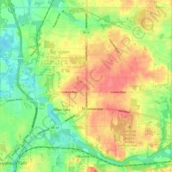
Name: Stow topographic map, elevation, terrain.

Location: Stow, Summit County, Ohio, United States (41.13556 -81.48975 41.20297 -81.39178)

Average elevation: 325 m

Minimum elevation: 294 m

Maximum elevation: 356 m

Other topographic maps

Click on a map to view its topography, its elevation and its terrain.

Boston

United States > Ohio > Summit County

Average elevation: 245 m

Greensburg

United States > Ohio > Summit County > Green

Average elevation: 358 m

Metz

United States > Ohio > Summit County > Stow

Average elevation: 318 m

Copley

United States > Ohio > Summit County

Average elevation: 318 m

Copley

United States > Ohio > Summit County

Average elevation: 318 m

Sagamore Hills

United States > Ohio > Summit County

Average elevation: 264 m

Maple Grove Park

United States > Ohio > Summit County > Hudson

Average elevation: 316 m

Decker Park

United States > Ohio > Summit County > Barberton

Average elevation: 304 m

Myersville

United States > Ohio > Summit County > Green

Average elevation: 342 m

Metz

United States > Ohio > Summit County > Stow

Average elevation: 318 m

Gear up for your next adventure:

🥾Light Trekking Boots - Supportive boots for multi-day treks
💡LED Camping Lantern - Illuminate your campsite with long-lasting lanterns
🥾Waterproof Hiking Shoes - Durable shoes for wet and rugged trails
🥤Collapsible Travel Cup - Saves space and weight in your mess kit
🧤Thermal Hiking Gloves - Grip-enhanced gloves for cold-weather altitude trekking

As an Amazon Associate, this site earns from qualifying purchases at no extra cost to you.