Geolocate

Viù topographic map

Click on the map to display elevation.

About this map

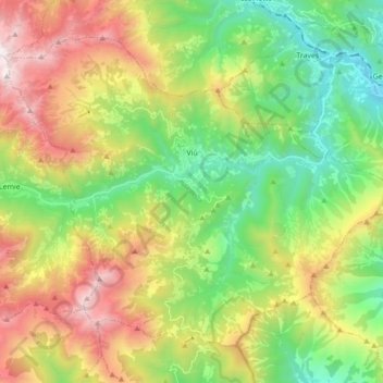
Name: Viù topographic map, elevation, terrain.

Location: Viù, Unione Montana Alpi Graie, Turin, Piedmont, Italy (45.17662 7.29101 45.27644 7.46660)

Average elevation: 1,223 m

Minimum elevation: 477 m

Maximum elevation: 2,397 m

Other topographic maps

Click on a map to view its topography, its elevation and its terrain.

Prarotto

Italy > Piedmont > Turin > Condove

Average elevation: 1,190 m

Turin

Italy > Piedmont > Turin

Average elevation: 295 m

Blanc

Italy > Piedmont > Turin > San Germano Chisone

Average elevation: 831 m

Turin

Italy > Piedmont > Turin

Average elevation: 295 m

Sportinia

Italy > Piedmont > Turin > Sauze d'Oulx

Average elevation: 2,015 m

La Cialma

Italy > Piedmont > Turin > Locana

Average elevation: 1,705 m

Pratobotrile

Italy > Piedmont > Turin > Condove

Average elevation: 1,117 m

Turin

Italy > Piedmont > Turin

Average elevation: 295 m

Rivetto

Italy > Piedmont > Turin > San Giorio di Susa

Average elevation: 583 m

Magnoletto

Italy > Piedmont > Turin > Condove

Average elevation: 699 m

Suppo

Italy > Piedmont > Turin > Rubiana

Average elevation: 1,350 m

Tornetti

Italy > Piedmont > Turin > Viù

Average elevation: 1,333 m

Baio Dora

Italy > Piedmont > Turin

Average elevation: 494 m

Famolasco

Italy > Piedmont > Turin

Average elevation: 508 m

Morelli

Italy > Piedmont > Turin > Gravere

Average elevation: 785 m

Belvedere

Italy > Piedmont > Turin > Borgiallo

Average elevation: 733 m

Gear up for your next adventure:

🥾Lightweight Hiking Boots - Boots for comfort and mobility on long hikes
📷Outdoor Action Camera - Capture high-elevation views and rugged adventures
🧥Packable Rain Jacket - Breathable waterproof layer for unpredictable weather
🔨Vehicle Emergency Tool - Safety tool for remote road trips to trailheads
🧦Merino Wool Socks - Moisture-wicking comfort for long-distance hiking

As an Amazon Associate, this site earns from qualifying purchases at no extra cost to you.