
Keserwan-Jbeil Governorate topographic map
Interactive map
Click on the map to display elevation.
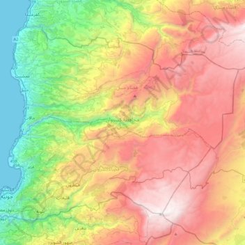
Keserwan-Jbeil Governorate topographic map, elevation, terrain
About this map
Name: Keserwan-Jbeil Governorate topographic map, elevation, terrain.
Location: Keserwan-Jbeil Governorate, Lebanon (33.94017 35.59808 34.21374 36.00960)
Average elevation: 1,201 m
Minimum elevation: 0 m
Maximum elevation: 2,617 m
Other topographic maps
Click on a map to view its topography, its elevation and its terrain.
Mount Lebanon
Mount Lebanon (Arabic: جَبَل لُبْنَان, jabal lubnān, Levantine Arabic pronunciation: [ˈʒabal lɪbˈneːn]; Syriac: ܛܘܪ ܠܒ݂ܢܢ, ṭūr leḇnān, Syriac pronunciation: [tˤur lewˈnɔn], ṭūr lewnōn) is a mountain range in Lebanon. It averages above 2,500 m (8,200 ft) in elevation,…
Average elevation: 2,819 m
Jezzine
Jezzine (Arabic: جزين Jizzīn) is a town in Lebanon, located 22 km (14 mi) from Sidon and 40 km (25 mi) south of Beirut. It is the capital of Jezzine District. Surrounded by mountain peaks, pine forests (like the Bkassine Pine Forest), and at an average altitude of 950 m (3,117 ft), it is the main summer…
Average elevation: 1,072 m
Beirut
The average annual rainfall is 825 millimetres (32.5 in), with the large majority of it falling from October to April. Much of the autumn and spring rain falls in heavy downpours on a limited number of days, but in winter it is spread more evenly over many days. Summer receives very little rainfall, if any.…
Average elevation: 145 m
Kfardebian
Lebanon > Keserwan-Jbeil Governorate
Kfardebian (Arabic: كفر دبيان; also spelled Kfar Dibiane and also known as Moucha'a Keserwan) is a municipality in the Keserwan District of the Keserwan-Jbeil Governorate in Lebanon. It is located 45 kilometers north of Beirut. Its average elevation is 1,220 meters above sea level and its total land…
Average elevation: 1,758 m
Faraya
Lebanon > Keserwan District > Faraya
Faraya (Arabic: فاريا) is a village and municipality in the Keserwan District of the Mount Lebanon Governorate, Lebanon. It is located 46 kilometers north of Beirut. Its average elevation is 1290 meters above sea level and its total land area is 870 hectares. Faraya's inhabitants are predominantly…
Average elevation: 1,846 m
Zahle
Zahlé is located 55 km (34 mi) east of the capital Beirut, close to the Beirut-Damascus road, and lies at the junction of the Lebanon mountains and the Beqaa plateau, at a mean elevation of 1,000 m. Zahlé is known as the "Bride of the Beqaa" and "the Neighbor of the Gorge" for its geographical location and…
Average elevation: 1,281 m