
Blat topographic map
Click on the map to display elevation.
About this map
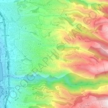
Name: Blat topographic map, elevation, terrain.
Location: Blat, Jbeil District, Keserwan-Jbeil Governorate, Lebanon (34.09855 35.65587 34.12319 35.70724)
Average elevation: 298 m
Minimum elevation: 0 m
Maximum elevation: 718 m
Other topographic maps
Click on a map to view its topography, its elevation and its terrain.
Kfardebian
Lebanon > Keserwan-Jbeil Governorate
Kfardebian (Arabic: كفر دبيان; also spelled Kfar Dibiane and also known as Moucha'a Keserwan) is a municipality in the Keserwan District of the Keserwan-Jbeil Governorate in Lebanon. It is located 45 kilometers north of Beirut. Its average elevation is 1,220 meters above sea level and its total land…
Average elevation: 1,758 m