
Keserwan District topographic map
Interactive map
Click on the map to display elevation.
About this map
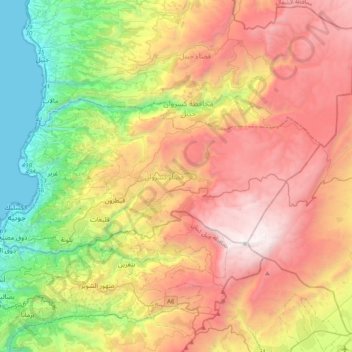
Name: Keserwan District topographic map, elevation, terrain.
Location: Keserwan District, Mount Lebanon Governorate, Lebanon (33.94017 35.59808 34.08619 35.99659)
Average elevation: 1,202 m
Minimum elevation: 0 m
Maximum elevation: 2,617 m
Other topographic maps
Click on a map to view its topography, its elevation and its terrain.
Faraya
Lebanon > Keserwan District > Faraya
Faraya (Arabic: فاريا) is a village and municipality in the Keserwan District of the Mount Lebanon Governorate, Lebanon. It is located 46 kilometers north of Beirut. Its average elevation is 1290 meters above sea level and its total land area is 870 hectares. Faraya's inhabitants are predominantly…
Average elevation: 1,846 m