Geolocate

Matn District topographic map

Click on the map to display elevation.

About this map

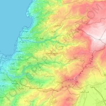
Name: Matn District topographic map, elevation, terrain.

Location: Matn District, Mount Lebanon Governorate, Lebanon (33.83953 35.52937 33.98039 35.89978)

Average elevation: 952 m

Minimum elevation: -2 m

Maximum elevation: 2,611 m

Other topographic maps

Click on a map to view its topography, its elevation and its terrain.

Baabda

Lebanon > Mount Lebanon Governorate

Average elevation: 211 m

Gear up for your next adventure:

🥾Approach Shoes - Shoes designed for climbing approaches and rugged trails
🔦LED Flashlight - Powerful and long-lasting flashlight for camping and emergencies
🧰Survival Kit - Essential gear for emergencies in the wilderness
🛏️Camping Sleeping Mat - Comfortable mats for sleeping outdoors
🧣Evaporative Cooling Towel - Beat the heat during intense summer climbs

As an Amazon Associate, this site earns from qualifying purchases at no extra cost to you.