
Make a donation
Gear up for your next adventure:
As an Amazon Associate, this site earns from qualifying purchases at no extra cost to you.
Upper Moreland Township topographic map
Click on the map to display elevation.
Make a donation
Gear up for your next adventure:
As an Amazon Associate, this site earns from qualifying purchases at no extra cost to you.
About this map
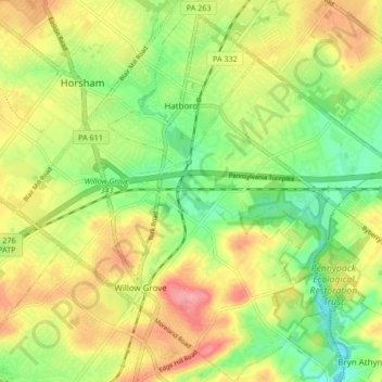
Name: Upper Moreland Township topographic map, elevation, terrain.
Average elevation: 83 m
Minimum elevation: 38 m
Maximum elevation: 134 m
Make a donation
Gear up for your next adventure:
As an Amazon Associate, this site earns from qualifying purchases at no extra cost to you.
Other topographic maps
Click on a map to view its topography, its elevation and its terrain.
Plymouth Meeting
United States > Pennsylvania > Montgomery County > Whitemarsh Township
Average elevation: 54 m
Three Tuns
United States > Pennsylvania > Montgomery County > Upper Dublin Township > Maple Glen
Average elevation: 101 m
Hidden Valley
United States > Pennsylvania > Montgomery County > Upper Merion Township
Average elevation: 47 m
Make a donation
Gear up for your next adventure:
As an Amazon Associate, this site earns from qualifying purchases at no extra cost to you.
Marble Hall
United States > Pennsylvania > Montgomery County > Whitemarsh Township
Average elevation: 64 m
Fagleysville
United States > Pennsylvania > Montgomery County > New Hanover Township
Average elevation: 105 m
Woxall
United States > Pennsylvania > Montgomery County > Upper Salford Township
Average elevation: 98 m
Fitzwatertown
United States > Pennsylvania > Montgomery County > Upper Dublin Township
Average elevation: 86 m
Make a donation
Gear up for your next adventure:
As an Amazon Associate, this site earns from qualifying purchases at no extra cost to you.
Lafayette Hill
United States > Pennsylvania > Montgomery County > Whitemarsh Township
Average elevation: 59 m
Huntingdon Valley
United States > Pennsylvania > Montgomery County > Lower Moreland Township
Average elevation: 65 m
Ashmead Village
United States > Pennsylvania > Montgomery County > Cheltenham Township > Cheltenham
Average elevation: 51 m
Make a donation
Gear up for your next adventure:
As an Amazon Associate, this site earns from qualifying purchases at no extra cost to you.
Gladwyne
United States > Pennsylvania > Montgomery County > Lower Merion Township
Average elevation: 92 m
Mont Clare
United States > Pennsylvania > Montgomery County > Upper Providence Township
Average elevation: 56 m
Evansburg State Park
United States > Pennsylvania > Montgomery County > Worcester Township > Cedars
Average elevation: 70 m
Bala Cynwyd
United States > Pennsylvania > Montgomery County > Lower Merion Township
Average elevation: 76 m
Make a donation
Gear up for your next adventure:
As an Amazon Associate, this site earns from qualifying purchases at no extra cost to you.
Penn Valley
United States > Pennsylvania > Montgomery County > Lower Merion Township > Ardmore
Average elevation: 89 m
Elkins Park Gardens
United States > Pennsylvania > Montgomery County > Cheltenham Township > Cheltenham
Average elevation: 70 m
Haverford
United States > Pennsylvania > Montgomery County > Lower Merion Township > Ardmore
Average elevation: 103 m
Gladwyne
United States > Pennsylvania > Montgomery County > Lower Merion Township
Average elevation: 92 m
Make a donation
Gear up for your next adventure:
As an Amazon Associate, this site earns from qualifying purchases at no extra cost to you.
Bryn Mawr
United States > Pennsylvania > Montgomery County > Lower Merion Township
Average elevation: 109 m
Lafayette Hill
United States > Pennsylvania > Montgomery County > Whitemarsh Township
Average elevation: 59 m
Dresher
United States > Pennsylvania > Montgomery County > Upper Dublin Township
Average elevation: 82 m
La Mott Community Center & Playground
United States > Pennsylvania > Montgomery County > Cheltenham Township > Lamott
Average elevation: 77 m
Make a donation
Gear up for your next adventure:
As an Amazon Associate, this site earns from qualifying purchases at no extra cost to you.
Arlingham
United States > Pennsylvania > Montgomery County > Springfield Township
Average elevation: 66 m
Hamilton Court
United States > Pennsylvania > Montgomery County > Lower Merion Township > Ardmore
Average elevation: 102 m
Upper Glasgow
United States > Pennsylvania > Montgomery County > West Pottsgrove Township
Average elevation: 86 m
Gladwyne
United States > Pennsylvania > Montgomery County > Lower Merion Township
Average elevation: 92 m
Make a donation
Gear up for your next adventure:
As an Amazon Associate, this site earns from qualifying purchases at no extra cost to you.
Edge Hill
United States > Pennsylvania > Montgomery County > Cheltenham Township > Glenside
Average elevation: 94 m
Brandywine Village
United States > Pennsylvania > Montgomery County > Upper Merion Township
Average elevation: 50 m
Franklinville
United States > Pennsylvania > Montgomery County > Whitpain Township
Average elevation: 94 m
Make a donation
Gear up for your next adventure:
As an Amazon Associate, this site earns from qualifying purchases at no extra cost to you.
Gwynedd Valley
United States > Pennsylvania > Montgomery County > Lower Gwynedd Township
Average elevation: 93 m
Huntingdon Valley
United States > Pennsylvania > Montgomery County > Lower Moreland Township
Average elevation: 65 m
Jeffersonville
United States > Pennsylvania > Montgomery County > West Norriton Township
Average elevation: 56 m
Make a donation
Gear up for your next adventure:
As an Amazon Associate, this site earns from qualifying purchases at no extra cost to you.
Morganville
United States > Pennsylvania > Montgomery County > Upper Moreland Township > Willow Grove
Average elevation: 81 m
Rydal Park
United States > Pennsylvania > Montgomery County > Abington Township
Average elevation: 87 m
Penn Wynne
United States > Pennsylvania > Montgomery County > Lower Merion Township
Average elevation: 76 m
Make a donation
Gear up for your next adventure:
As an Amazon Associate, this site earns from qualifying purchases at no extra cost to you.
Betzwood
United States > Pennsylvania > Montgomery County > West Norriton Township
Average elevation: 48 m
Bala Cynwyd
United States > Pennsylvania > Montgomery County > Lower Merion Township
Average elevation: 75 m
Mainland
United States > Pennsylvania > Montgomery County > Lower Salford Township
Average elevation: 79 m
Penllyn
United States > Pennsylvania > Montgomery County > Lower Gwynedd Township
Average elevation: 85 m
Make a donation
Gear up for your next adventure:
As an Amazon Associate, this site earns from qualifying purchases at no extra cost to you.
Willow Grove
United States > Pennsylvania > Montgomery County > Upper Moreland Township
Average elevation: 91 m
Unami Creek
United States > Pennsylvania > Montgomery County > Marlborough Township
Average elevation: 125 m
Wynmere Downs
United States > Pennsylvania > Montgomery County > Horsham Township
Average elevation: 98 m
Eagleville
United States > Pennsylvania > Montgomery County > Lower Providence Township
Average elevation: 102 m
Make a donation
Gear up for your next adventure:
As an Amazon Associate, this site earns from qualifying purchases at no extra cost to you.
Belmont Terrace
United States > Pennsylvania > Montgomery County > Upper Merion Township > King of Prussia
Average elevation: 45 m
Gwynedd
United States > Pennsylvania > Montgomery County > Lower Gwynedd Township
Average elevation: 111 m
New Hanover
United States > Pennsylvania > Montgomery County > New Hanover Township
Average elevation: 91 m
Make a donation
Gear up for your next adventure:
As an Amazon Associate, this site earns from qualifying purchases at no extra cost to you.
Elkins Park Gardens
United States > Pennsylvania > Montgomery County > Cheltenham Township > Cheltenham
Average elevation: 70 m
Oreland
United States > Pennsylvania > Montgomery County > Upper Dublin Township
Average elevation: 80 m
Lafayette Park
United States > Pennsylvania > Montgomery County > King of Prussia > Lafayette Park
Average elevation: 54 m
Ashbourne
United States > Pennsylvania > Montgomery County > Cheltenham Township
Average elevation: 70 m
Make a donation
Gear up for your next adventure:
As an Amazon Associate, this site earns from qualifying purchases at no extra cost to you.
Albidale
United States > Pennsylvania > Montgomery County > Lower Moreland Township > Albidale
Average elevation: 77 m
Mount Joy
United States > Pennsylvania > Montgomery County > Upper Merion Township
Average elevation: 69 m
Haverford
United States > Pennsylvania > Montgomery County > Lower Merion Township > Ardmore
Average elevation: 103 m
Mainland
United States > Pennsylvania > Montgomery County > Lower Salford Township
Average elevation: 79 m
Make a donation
Gear up for your next adventure:
As an Amazon Associate, this site earns from qualifying purchases at no extra cost to you.
Village of Mingo
United States > Pennsylvania > Montgomery County > Upper Providence Township
Average elevation: 70 m
Bergey
United States > Pennsylvania > Montgomery County > Upper Salford Township
Average elevation: 93 m
Palm
United States > Pennsylvania > Montgomery County > Upper Hanover Township
Average elevation: 131 m