Geolocate

Rydal topographic map

Click on the map to display elevation.

About this map

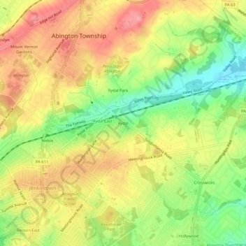
Name: Rydal topographic map, elevation, terrain.

Location: Rydal, Abington Township, Montgomery County, Pennsylvania, 19046, United States (40.08643 -75.12857 40.12643 -75.08857)

Average elevation: 84 m

Minimum elevation: 33 m

Maximum elevation: 127 m

Other topographic maps

Click on a map to view its topography, its elevation and its terrain.

Gear up for your next adventure:

🧥Fleece Jacket - Warm and lightweight jacket for layering
🗺️Topographic Maps - Detailed maps to explore trails, mountains, and wilderness areas
🧭Orienteering Kit - Tools for map reading and navigation in the wild
Camping Essentials - All-in-one gear for a comfortable camping trip
💧Hydration Pack - Hands-free hydration system for long hikes

As an Amazon Associate, this site earns from qualifying purchases at no extra cost to you.