
Mainland topographic map
Click on the map to display elevation.
About this map
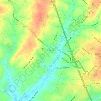
Name: Mainland topographic map, elevation, terrain.
Average elevation: 79 m
Minimum elevation: 54 m
Maximum elevation: 104 m
Other topographic maps
Click on a map to view its topography, its elevation and its terrain.
Harleysville
United States > Pennsylvania > Montgomery County > Lower Salford Township > Harleysville
Average elevation: 90 m
Harleysville
United States > Pennsylvania > Montgomery County > Lower Salford Township > Harleysville
Average elevation: 90 m
Harleysville
United States > Pennsylvania > Montgomery County > Lower Salford Township > Harleysville
Average elevation: 90 m