Geolocate

Jiahe County topographic map

Click on the map to display elevation.

About this map

Name: Jiahe County topographic map, elevation, terrain.

Location: Jiahe County, Chenzhou, Hunan, China (25.43818 112.23170 25.79041 112.58915)

Average elevation: 312 m

Minimum elevation: 128 m

Maximum elevation: 1,517 m

Other topographic maps

Click on a map to view its topography, its elevation and its terrain.
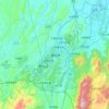
Chenzhou

China > Hunan > Chenzhou

Average elevation: 364 m

Guanxi

China > Hunan > Chenzhou

Average elevation: 392 m

Pule

China > Hunan > Chenzhou

Average elevation: 850 m

Mangshan

China > Hunan > Chenzhou

Average elevation: 739 m

Gear up for your next adventure:

⛺Backpacking Tent - Lightweight tent for long-distance hiking trips
🧦Hiking Liner Socks - Thin base layer to prevent friction and blisters
🥾Approach Shoes - Shoes designed for climbing approaches and rugged trails
🧳Compression Sacks - Maximize space in your backpack by shrinking gear
🚲Heavy Duty Bike Lock - Secure your bike at the trailhead or during stops

As an Amazon Associate, this site earns from qualifying purchases at no extra cost to you.