Geolocate

Eldorado topographic map

Click on the map to display elevation.

About this map

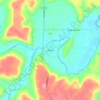
Name: Eldorado topographic map, elevation, terrain.

Location: Eldorado, Fayette County, Iowa, United States (43.03053 -91.85544 43.07053 -91.81544)

Average elevation: 314 m

Minimum elevation: 272 m

Maximum elevation: 381 m

Other topographic maps

Click on a map to view its topography, its elevation and its terrain.

Elgin

United States > Iowa > Fayette County

Average elevation: 261 m

Westgate

United States > Iowa > Fayette County

Average elevation: 333 m

Hawkeye

United States > Iowa > Fayette County

Average elevation: 352 m

Westgate

United States > Iowa > Fayette County

Average elevation: 333 m

West Union

United States > Iowa > Fayette County

Average elevation: 350 m

Westgate

United States > Iowa > Fayette County

Average elevation: 333 m

Maynard

United States > Iowa > Fayette County

Average elevation: 340 m

Westgate

United States > Iowa > Fayette County

Average elevation: 333 m

Gear up for your next adventure:

🗺️Topographic Maps - Detailed maps to explore trails, mountains, and wilderness areas
🥾Trekking Poles - Adjustable trekking poles to reduce knee stress and improve stability
🧣Evaporative Cooling Towel - Beat the heat during intense summer climbs
🧴Outdoor Sunscreen - High SPF protection for high-altitude UV exposure
🛏️Camping Sleeping Mat - Comfortable mats for sleeping outdoors

As an Amazon Associate, this site earns from qualifying purchases at no extra cost to you.