Geolocate

Luzon topographic map

Click on the map to display elevation.

About this map

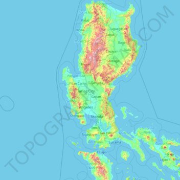
Name: Luzon topographic map, elevation, terrain.

Location: Luzon, Central Luzon, Philippines (12.53287 119.74983 18.65129 124.19838)

Average elevation: 88 m

Minimum elevation: -1 m

Maximum elevation: 2,758 m

Other topographic maps

Click on a map to view its topography, its elevation and its terrain.

Quezon City

Philippines

Founded as a pueblo by Saint Pedro Bautista in 1590, San Francisco del Monte may be considered Quezon City's oldest district. The original land area of the old town of San Francisco del Monte was approximately2.5 square kilometres (1.0 sq mi) and covered parts of what is currently known as Project 7 and 8 and…

Average elevation: 57 m

Baguio

Philippines

In 1903, Filipinos, Japanese and Chinese workers were hired to build Kennon Road, the first road directly connecting Baguio with the lowlands of La Union and Pangasinan. Before this, the only road to Benguet was Naguilian Road, and it was largely a horse trail at higher elevations. Camp John Hay was…

Average elevation: 881 m

Valencia

Philippines > Bukidnon

The city's topography is characterized as flat to undulating hills with extensive plateaus and mountainous areas and cliffs on both eastern and western portions bounding the municipality of San Fernando on the east and the municipality of Talakag on the west. Its highest point is Mount Kalatungan in the…

Average elevation: 566 m

Lapu-Lapu

Philippines

Average elevation: 93 m

Cebu City

Philippines > Cebu > Cebu City

Average elevation: 140 m

Balubad

Philippines > Cavite > Silang

Average elevation: 377 m

Oas

Philippines > Albay

Average elevation: 39 m

Cabadbaran

Philippines > Agusan del Norte

It is 29 kilometres (18 mi) from Butuan. It is generally flat with rolling hills and swamplands in its western part. The highest of all mountains in the Caraga region, Mount Hilong-Hilong (with an altitude of 2,012 metres (6,601 ft) above sea level), rises in this city.

Average elevation: 179 m

Poro Point

Philippines > La Union > San Fernando

Average elevation: 2 m

Macasandig

Philippines

Average elevation: 42 m

Bohol

Philippines

Average elevation: 116 m

Albay

Philippines

Average elevation: 48 m

Cebu

Philippines

Average elevation: 89 m

Kiamba

Philippines > Sarangani

Average elevation: 55 m

Angadanan

Philippines > Isabela

Average elevation: 63 m

Hinunangan

Philippines > Southern Leyte

Hinunangan is home to the highest mountain in the province, Mount Nacolod, with an elevation of 948 metres (3,110 ft) above sea level.

Average elevation: 35 m

Kinatihan II

Philippines

Average elevation: 22 m

Pasig

Philippines

Average elevation: 46 m

Samar

Philippines

Average elevation: 38 m

Bulacan

Philippines

Average elevation: 105 m

Valenzuela

Philippines

The highest elevation point is 38 meters (125 ft) above sea level. Having a surface gradient of 0.55% and a gentle slope, hilly landscape is located in the industrial section of the city in Canumay. The average elevation point is 2 meters (6.6 ft) above sea level.

Average elevation: 24 m

Lingayen

Philippines > Pangasinan

Average elevation: 4 m

Pozorrubio

Philippines > Pangasinan

Average elevation: 61 m

Naguilian

Philippines > La Union

The approximate elevation of the municipality is 165 meters above sea level. It has the ninth highest approximate average elevation among the twenty (20) towns of the province. The portion with the highest elevation is 544 meters above sea level while the lowest is 10 meters. The slopes range from 2–7% in…

Average elevation: 85 m

Daraga

Philippines > Albay

67.3% of the total municipal land area has a predominantly low elevation of up to 100 metres (330 ft). The surface terrain is generally characterized by combination of level to nearly level areas, gentle to undulating areas and undulating to rolling areas.

Average elevation: 76 m

Sorsogon City

Philippines > Sorsogon

Sorsogon City covers a land area of 31,292 hectares (120.82 sq mi). It is at the southernmost tip of the Bicol Peninsula and of Luzon Island. The city is bounded by Castilla in the west, Manito in the northwest, Albay Gulf in the north, Prieto Diaz in the east, Gubat in the southeast, Casiguran in the…

Average elevation: 89 m

El Nido

Philippines > Palawan

Average elevation: 33 m

Patag Island

Philippines

Average elevation: 0 m

Kota Island

Philippines

Average elevation: 0 m

Lankiam Cay

Philippines

Average elevation: 0 m

Iriga

Philippines

Average elevation: 115 m

Davao Gulf

Philippines

Average elevation: 0 m

Malainen Luma

Philippines > Cavite > Naic

Average elevation: 54 m

Didicas Volcano

Philippines > Cagayan > Calayan

Didicas is topped with a lava dome with an elevation of 228 metres (748 ft) and a base diameter of 1,200 metres (3,900 ft) at sea level. It is at the southern end of the Luzon Volcanic Arc, and like all the volcanoes in the Philippines, is part of the Pacific ring of fire.

Average elevation: 7 m

Lawak Island

Philippines

Average elevation: 0 m

Surigao del Sur

Philippines

Average elevation: 274 m

Candaba

Philippines

Average elevation: 6 m

Davao City

Philippines

Average elevation: 65 m

Ibabang Bukal

Philippines

Average elevation: 254 m

Cabatang

Philippines

Average elevation: 335 m

Pinget

Philippines

Average elevation: 1,430 m

Caloocan

Philippines

Average elevation: 81 m

Aurora Hill North Central

Philippines

Average elevation: 1,479 m

Besigan

Philippines

Average elevation: 584 m

Talomo River

Philippines

Average elevation: 201 m

Asin

Philippines

Average elevation: 1,321 m

Catambungan

Philippines

Average elevation: 5 m

Tablas Strait

Philippines

Average elevation: 0 m

Buenavista

Philippines

Average elevation: 112 m

Poliwes

Philippines

Average elevation: 1,397 m

Teodora Alonzo

Philippines

Average elevation: 1,459 m

Manggahan

Philippines

Average elevation: 7 m

Bakakeng Norte

Philippines

Average elevation: 1,379 m

New Carmen

Philippines

Average elevation: 98 m

Crossing Bayabas

Philippines

Average elevation: 22 m

Taguig

Philippines

Average elevation: 39 m

Marinduque

Philippines

Average elevation: 54 m

Bakakeng Central

Philippines

Average elevation: 1,412 m

Tarlac

Philippines

Average elevation: 109 m

Parañaque

Philippines

Average elevation: 14 m

Pacdal

Philippines

Average elevation: 1,448 m

Batanes

Philippines

Average elevation: 26 m

Nueva Ecija

Philippines

Average elevation: 112 m

Nueva Vizcaya

Philippines

Average elevation: 107 m

Antique

Philippines

Average elevation: 46 m

Zone IV

Philippines

Average elevation: 4 m

Sorsogon

Philippines

Average elevation: 40 m

Camarines Sur

Philippines

Average elevation: 56 m

Mines View

Philippines

Average elevation: 1,431 m

Masbate

Philippines

Average elevation: 54 m

City Camp Proper

Philippines

Average elevation: 1,430 m

Palawan

Philippines

Average elevation: 9 m

Zamboanga del Sur

Philippines

Average elevation: 118 m

Leyte

Philippines

Average elevation: 54 m

Quirino

Philippines

Average elevation: 108 m

Cavite

Philippines

Average elevation: 77 m

Isabela

Philippines

Average elevation: 100 m

Mount Palanan

Philippines

Average elevation: 913 m

Magat River

Philippines

Average elevation: 46 m

Las Piñas

Philippines

Average elevation: 14 m

Rizal

Philippines

Average elevation: 95 m

Samal Island

Philippines > Davao del Norte > Samal

Average elevation: 117 m

Pasig River

Philippines

Average elevation: 21 m

Leyte Gulf

Philippines

Average elevation: 0 m

Mandaue

Philippines

It is one of the two (the other one being the municipality of Consolacion) local government units located within the mainland Metro Cebu where the elevation of land is less than 100 m (330 ft).

Average elevation: 109 m

Lucban

Philippines

Average elevation: 504 m

Iligan

Philippines

Average elevation: 229 m

Davao City

Philippines

Average elevation: 56 m

Upper Tominobo

Philippines > Iligan

Average elevation: 166 m

Tagaytay

Philippines > Cavite

The southern and eastern portions of Tagaytay are covered by hills and mountains which is generally forests, pine trees and open grasslands. The city lies along Tagaytay Ridge, a ridge stretching about 32 kilometres (20 mi) from Mount Batulao in the west to Mount Sungay in the east with elevations averaging…

Average elevation: 229 m

San Juan

Philippines

"San Juan" is a contraction of the city's traditional name of "San Juan del Monte" (lit. 'Saint John of the Mountain'). As with numerous other places in the Philippines, the name combines a patron saint and a toponym; in this case Saint John the Baptist with the locale's hilly terrain and relatively higher…

Average elevation: 35 m

Pasay

Philippines

Average elevation: 14 m

Bacolod

Philippines

Bacólod (English: Bacolod), is derived from bakólod (Old Spelling: bacólod), the Old Hiligaynon (Old Ilonggo) (Old Spelling: Ylongo and Ilongo) word for a "hill, turtle, mound, rise, hillock, down, any small eminence or elevation", since the resettlement was founded on a stony, hilly area, now the barangay…

Average elevation: 49 m

Mandaluyong

Philippines

Another claims that the Spaniards named the place based on the report of a navigator named Acapulco, who saw the rolling hills frequently being lashed at by daluyong (“big waves from the sea”). This seems to confirm traditional pre-Hispanic stories that giant waves from the sea would meet the adjoining…

Average elevation: 33 m

San Fernando

Philippines > Pampanga

Average elevation: 24 m

Butuan

Philippines

Average elevation: 115 m

Marikina

Philippines

Average elevation: 80 m

Pambuhan

Philippines

Average elevation: 33 m

Sapa

Philippines > Cavite > Naic

Average elevation: 9 m

Kibungan

Philippines > Benguet

The municipality is within a cool highland mountainous zone with elevations at more than 2,500 metres (8,200 ft) above sea level. During its coolest months of December to January, Barangay Madaymen experiences chilling temperature of 0 °C (32 °F), causing the famous Frost of Madaymen.

Average elevation: 1,249 m

Gear up for your next adventure:

Tent Footprint - Protect tent floor and increase durability
🪑Ultralight Camping Stool - Compact seating for rest stops during long hikes
🗺️Topographic Maps - Detailed maps to explore trails, mountains, and wilderness areas
🥾Approach Boots - Comfortable boots for hiking and climbing approaches
🧢Hiking Sun Hat - Wide-brimmed protection for exposed mountain ridges

As an Amazon Associate, this site earns from qualifying purchases at no extra cost to you.