Geolocate

Biñan topographic map

Click on the map to display elevation.

About this map

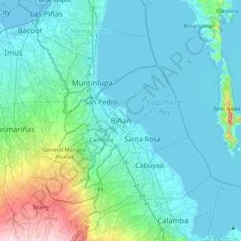
Name: Biñan topographic map, elevation, terrain.

Location: Biñan, Laguna, Calabarzon, 4024, Philippines (14.17851 120.92360 14.49851 121.24360)

Average elevation: 59 m

Minimum elevation: -4 m

Maximum elevation: 423 m

Other topographic maps

Click on a map to view its topography, its elevation and its terrain.

Splash Island

Philippines > Laguna > Biñan

Average elevation: 21 m

Gear up for your next adventure:

🪑Insulated Seat Pad - Protect your seat from cold rocks and wet logs
🔦UV Flashlight - Detect minerals or specific insects in the dark
🔦LED Headtorch - Bright and durable light for night activities
🩹Compact First Aid Kit - Pre-packed essentials for common trail injuries
🔭Compact Monocular - One-handed bird watching and trail spotting

As an Amazon Associate, this site earns from qualifying purchases at no extra cost to you.