Geolocate

Cadiz topographic map

Click on the map to display elevation.

About this map

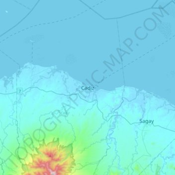
Name: Cadiz topographic map, elevation, terrain.

Location: Cadiz, Negros Occidental, Western Visayas, 6121, Philippines (10.79665 123.14570 11.11665 123.46570)

Average elevation: 68 m

Minimum elevation: -3 m

Maximum elevation: 1,326 m

Other topographic maps

Click on a map to view its topography, its elevation and its terrain.

Gear up for your next adventure:

🧴Sunscreen SPF - Broad-spectrum sunscreen for outdoor activities
🧴Insect Repellent - Protect yourself from bugs during outdoor adventures
📷Outdoor Action Camera - Capture high-elevation views and rugged adventures
🥾Durable Hiking Shoes - Long-lasting shoes for frequent hiking
🧥Waterproof Hiking Jacket - Protect yourself from rain and wind while hiking

As an Amazon Associate, this site earns from qualifying purchases at no extra cost to you.