
Rannoch Moor topographic map
Interactive map
Click on the map to display elevation.
About this map
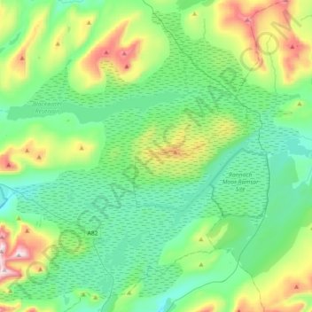
Name: Rannoch Moor topographic map, elevation, terrain.
Location: Rannoch Moor, Perth and Kinross, Scotland, United Kingdom (56.58204 -4.88690 56.76598 -4.52996)
Average elevation: 429 m
Minimum elevation: 212 m
Maximum elevation: 1,100 m
Other topographic maps
Click on a map to view its topography, its elevation and its terrain.
Pitlochry
United Kingdom > Scotland > Perth and Kinross
Pitlochry, Perth and Kinross, Scotland, PH16 5BX, United Kingdom
Average elevation: 276 m
Rait Village
United Kingdom > Scotland > Perth and Kinross > Rait
Rait Village, Rait, Perth and Kinross, Scotland, United Kingdom
Average elevation: 81 m
Guildtown
United Kingdom > Scotland > Perth and Kinross
Guildtown, Perth and Kinross, Scotland, PH2 6FP, United Kingdom
Average elevation: 80 m
Bridge of Balgie
United Kingdom > Scotland > Perth and Kinross
Bridge of Balgie, Perth and Kinross, Scotland, PH15 2PT, United Kingdom
Average elevation: 395 m
Killiecrankie
United Kingdom > Scotland > Perth and Kinross
Killiecrankie, Perth and Kinross, Scotland, PH16 5GZ, United Kingdom
Average elevation: 285 m
Morenish
United Kingdom > Scotland > Perth and Kinross
Morenish, Perth and Kinross, Scotland, FK21 8TL, United Kingdom
Average elevation: 255 m
Hatton
United Kingdom > Scotland > Perth and Kinross
Hatton, Perth and Kinross, Scotland, PH2 6DX, United Kingdom
Average elevation: 69 m
Dron
United Kingdom > Scotland > Perth and Kinross > Bridge of Earn
Dron, Bridge of Earn, Perth and Kinross, Scotland, PH2 9HG, United Kingdom
Average elevation: 81 m
Wolfhill
United Kingdom > Scotland > Perth and Kinross
Wolfhill, Perth and Kinross, Scotland, PH2 6TH, United Kingdom
Average elevation: 118 m
Aberargie
United Kingdom > Scotland > Perth and Kinross
Aberargie, Perth and Kinross, Scotland, PH2 9ND, United Kingdom
Average elevation: 74 m
Upper Glendevon Reservoir
United Kingdom > Scotland > Perth and Kinross
Upper Glendevon Reservoir, Backhill, Perth and Kinross, Scotland, United Kingdom
Average elevation: 414 m
The Birks of Aberfeldy
United Kingdom > Scotland > Perth and Kinross > Aberfeldy
The Birks of Aberfeldy, Aberfeldy, Perth and Kinross, Scotland, United Kingdom
Average elevation: 222 m
Campmuir
United Kingdom > Scotland > Perth and Kinross
Campmuir, Perth and Kinross, Scotland, PH13 9JG, United Kingdom
Average elevation: 73 m
Longforgan
United Kingdom > Scotland > Perth and Kinross
Longforgan, Perth and Kinross, Scotland, DD2 5EU, United Kingdom
Average elevation: 29 m
Beinn a' Chreachain
United Kingdom > Scotland > Perth and Kinross
Beinn a' Chreachain, Perth and Kinross, Scotland, United Kingdom
Average elevation: 708 m
Milton of Edradour
United Kingdom > Scotland > Perth and Kinross > Kinnaird
Milton of Edradour, Kinnaird, Perth and Kinross, Scotland, PH16 5JW, United Kingdom
Average elevation: 216 m
Crook of Devon
United Kingdom > Scotland > Perth and Kinross
Crook of Devon, Perth and Kinross, Scotland, KY13 0UJ, United Kingdom
Average elevation: 160 m
Perth
United Kingdom > Scotland > Perth and Kinross
Perth, Perth and Kinross, Scotland, PH1 5SU, United Kingdom
Average elevation: 131 m
Braco
United Kingdom > Scotland > Perth and Kinross
Braco, Perth and Kinross, Scotland, FK15 9QJ, United Kingdom
Average elevation: 132 m
Elcho Castle
United Kingdom > Scotland > Perth and Kinross > Perth > Rhynd
Elcho Castle, Rhynd, Perth, Perth and Kinross, Scotland, PH2 8QQ, United Kingdom
Average elevation: 38 m
Glen Lyon
United Kingdom > Scotland > Perth and Kinross
Glen Lyon, Perth and Kinross, Scotland, United Kingdom
Average elevation: 461 m
Balvaird Castle
United Kingdom > Scotland > Perth and Kinross
Balvaird Castle, Millden Road, Perth and Kinross, Scotland, KY14 7SR, United Kingdom
Average elevation: 178 m
Crieff
United Kingdom > Scotland > Perth and Kinross
Crieff, Perth and Kinross, Scotland, PH7 3BS, United Kingdom
Average elevation: 115 m
Auchterarder
United Kingdom > Scotland > Perth and Kinross
Auchterarder, Perth and Kinross, Scotland, PH3 1BJ, United Kingdom
Average elevation: 123 m
Burleigh Castle
United Kingdom > Scotland > Perth and Kinross > Milnathort
Burleigh Castle, Burleigh Road, Milnathort, Perth and Kinross, Scotland, KY13 9SU, United Kingdom
Average elevation: 120 m
St Davids
United Kingdom > Scotland > Perth and Kinross
St Davids, Perth and Kinross, Scotland, PH7 3PJ, United Kingdom
Average elevation: 69 m
Charlottefield
United Kingdom > Scotland > Perth and Kinross > Ballinluig
Charlottefield, Ballinluig, Perth and Kinross, Scotland, PH9 0PB, United Kingdom
Average elevation: 196 m
Collace
United Kingdom > Scotland > Perth and Kinross
Collace, Perth and Kinross, Scotland, PH2 6JB, United Kingdom
Average elevation: 165 m
Aberfeldy
United Kingdom > Scotland > Perth and Kinross
Aberfeldy, Perth and Kinross, Scotland, PH15 2DD, United Kingdom
Average elevation: 304 m
Kinnesswood
United Kingdom > Scotland > Perth and Kinross
Kinnesswood, Perth and Kinross, Scotland, KY13 9HJ, United Kingdom
Average elevation: 197 m
Loch Leven
United Kingdom > Scotland > Perth and Kinross > Kinross
Loch Leven, Kinross, Perth and Kinross, Scotland, United Kingdom
Average elevation: 114 m
Abernethy
United Kingdom > Scotland > Perth and Kinross
Abernethy, Perth and Kinross, Scotland, PH2 9JL, United Kingdom
Average elevation: 95 m
Tummel Bridge
United Kingdom > Scotland > Perth and Kinross
Tummel Bridge, Perth and Kinross, Scotland, PH16 5SA, United Kingdom
Average elevation: 273 m
Kinfauns
United Kingdom > Scotland > Perth and Kinross > Perth
Kinfauns, Perth, Perth and Kinross, Scotland, PH2 7LD, United Kingdom
Average elevation: 83 m
River Tay
United Kingdom > Scotland > Perth and Kinross
River Tay, Perth and Kinross, Scotland, United Kingdom
Average elevation: 213 m
Comrie
United Kingdom > Scotland > Perth and Kinross
Comrie, Perth and Kinross, Scotland, PH6 2EB, United Kingdom
Average elevation: 111 m
Blackford
United Kingdom > Scotland > Perth and Kinross
Blackford, Perth and Kinross, Scotland, PH4 1QE, United Kingdom
Average elevation: 161 m
Dunkeld
United Kingdom > Scotland > Perth and Kinross
Dunkeld, Perth and Kinross, Scotland, PH8 0AL, United Kingdom
Average elevation: 190 m
Errol
United Kingdom > Scotland > Perth and Kinross
Errol, Perth and Kinross, Scotland, PH2 7QW, United Kingdom
Average elevation: 13 m
Invergeldie
United Kingdom > Scotland > Perth and Kinross
Invergeldie, Perth and Kinross, Scotland, PH6 2LY, United Kingdom
Average elevation: 376 m
Rait
United Kingdom > Scotland > Perth and Kinross
Rait, Perth and Kinross, Scotland, PH2 7RT, United Kingdom
Average elevation: 91 m
Loch Leven National Nature Reserve
United Kingdom > Scotland > Perth and Kinross > Kinross
Loch Leven National Nature Reserve, Kinross, Perth and Kinross, Scotland, KY13 9LX, United Kingdom
Average elevation: 119 m
Blairgowrie and Rattray
United Kingdom > Scotland > Perth and Kinross
Blairgowrie and Rattray, Perth and Kinross, Scotland, PH10 6AB, United Kingdom
Average elevation: 121 m
Loch Tay
United Kingdom > Scotland > Perth and Kinross > Kenmore
Loch Tay, Kenmore, Perth and Kinross, Scotland, United Kingdom
Average elevation: 460 m
Meikle Obney
United Kingdom > Scotland > Perth and Kinross
Meikle Obney, Perth and Kinross, Scotland, PH1 4AS, United Kingdom
Average elevation: 161 m
Bertha Park
United Kingdom > Scotland > Perth and Kinross
Bertha Park, Perth and Kinross, Scotland, PH1 0AG, United Kingdom
Average elevation: 37 m
Loch Rannoch
United Kingdom > Scotland > Perth and Kinross > Kinloch Rannoch
Loch Rannoch, Kinloch Rannoch, Perth and Kinross, Scotland, United Kingdom
Average elevation: 469 m
Dalguise
United Kingdom > Scotland > Perth and Kinross
Dalguise, Perth and Kinross, Scotland, PH8 0JU, United Kingdom
Average elevation: 211 m
Glen Shee
United Kingdom > Scotland > Perth and Kinross > Spittal of Glenshee
Glen Shee, Spittal of Glenshee, Perth and Kinross, Scotland, United Kingdom
Average elevation: 387 m
Inchture
United Kingdom > Scotland > Perth and Kinross
Inchture, Perth and Kinross, Scotland, PH14 9SD, United Kingdom
Average elevation: 22 m